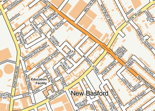
As well as the Egyptian quarter, a number of streets in New Basford in Nottingham are named after the Zulu War of 1879. As far as I can tell, in this area, there are seven of them, namely Chard Street, Chelmsford Road, Durnford Street, Ekowe Street, Isandula Road, Zulu Road and perhaps Eland Street.

What is most amazing about these streets is that they represent, as far as I can tell, a kind of salute to the Zulus, who were, as I mentioned previously, one of the finest and most valiant of all the opponents of the British Army. The Battle of Isandlwana, or Isandula, for example, was the greatest defeat ever suffered by British soldiers against a native force armed with their traditional weapons.
And the Zulus were trustworthy, too. King Cetshwayo tried as best he could to avoid war and told his men not to kill anybody who was not dressed in a red coat and therefore could not be identified with any certainty as a British soldier. He told them not to cross the border into Natal in pursuit of Chelmsford’s defeated forces. The Zulus stuck to both of these promises they had made to their king. Men in dark blue or green uniforms, such as in the Hale rocket battery, were allowed to walk away in peace, and not a single Zulu pursued the remnants of the defeated British army into Natal. If they had done, as Prince Ndanbuko urged them to, there would have been every chance of another stunning victory over the British Empire. Here’s Isandula Road:

So when we walk down Isandula Road, we can all remember that this Victorian street is a memorial to the Empire’s greatest ever native opponents. Had Isandlwana been an easier word to pronounce, of course, the street would have been called Isandlwana Road.
And I really do stick by the idea that this road was a monument to the Zulu warriors. There is only one Isandula Road in the whole of England so it must have been very important name to whoever made the decision to have a road dedicated to the British Empire’s gallant opponents. The same can be said of Zulu Road. There is only one of those in the whole country too :

I kept my eyes open for a Zulu or Tu, but I saw nothing. Here’s a modern Zulu, dressed up for the tourists, with all his friends:

He’s parked his car on the road in the background, which is quite a long way away. No wonder he’s had to keep his best trainers on.
By 1880, people in England were well aware of whose fault the calamitous defeat at Isandlwana was. It was Lord Chelmsford’s, so a road named after him must have served as much as a reminder of his failures and his shortcomings as a monument to his military genius. I would think that nowadays Chelmsford would be more famous as the uncle of Ernest Thesiger, the actor (left) who worked with James Whale in the latter’s Frankenstein films :

Here is Chelmsford Road, with Lord Chelmsford making good his escape from Isandlwana on his trusty bicycle:

Chelmsford Road may not look as if it is 140 years old, but it does have one feature that is straight from the 1880s. That is the arrangement of four, or perhaps six, houses, in a short row, all of them typical small working class “two up, two down” terraced houses. These four/six houses are opposite an identical set of houses, with, in this case, a concrete courtyard between the two rows. The more usual pattern was to have the outside lavatories situated in the middle of that courtyard, equidistant from each set of houses. In the golden days of the earth closet, this must have given life a very distinctive flavour, particularly in the summer.
This particular set of houses is called “Chelmsford Terrace” in honour of the great man. This particular section of Chelmsford Road has other sets of houses like these, one called “Rene Terrace”, and another, “Iris Terrace”:

Here is Durnford Street, all of it:

Anthony Durnford was one of the two subordinate commanders killed at Isandlwana (the other was Henry Pulleine). Chelmsford was quick to blame Durnford for disobeying his superior’s orders to set up a proper defensible camp, although there is actually no hard evidence whatsoever that Chelmsford ever issued such an order. Nevertheless, Durnford can be regarded as a rather unsuccessful soldier, just like Chelmsford. He was also Irish, so, by the racist attitudes of the time, he was an easy man to blame. He was also dead, so he couldn’t argue with any of Chelmsford’s lies.
Chard Street is not always marked on street maps for some reason. It runs at right angles to Isandula Road, Chelmsford Road and Zulu Road. It is marked by the Orange Arrow’s “New Friend”, the Red Hot Air Balloon:

Here is Chard Street. It certainly has a Zululand feel about it:

John Chard is really the only heroic figure in this war to have a street named after him. He was the commander at Rorke’s Drift. He was played by Stanley Baker :

Chard’s second-in-command was Gonville Bromhead, now better known as Sir Michael Caine. Sadly, there was no street named after him. Bromhead was, in actual fact, an Old Boy of Magnus Grammar School in Newark-on-Trent:

There is also an Eland Street fairly close by. This street probably fits in with all of these other South African links. An Eland is a large antelope which would surely have provided food for members of both armies.

Here is the map for Eland Street, which has an Orange Assegai at its northern end.
Ekowe Street is named after another incident in the Zulu War of 1879…….
On the very same day as the defeat at Isandlwana, 6,570 British soldiers armed with rifles, rockets and field guns managed to defeat a Zulu army of around 10,000 men armed with assegais and cowhide shields. They occupied Ekowe, where they were then besieged by the Zulus for ten weeks before a British army of 5,670 men came to the rescue with their two 9-pounder guns, four 24-pounder Congreve rocket tubes and two Gatling guns. You can see a rocket being fired in this picture:

Incidentally, I cannot find any connection for Liddington Street, Monsall Street or Pearson Street.
Just look though, what rich roots many English street names have.
Just look at the map above. “Ford Street North” where one of Henry Ford’s brothers was probably born. “Camelot Avenue” where Queen Guinevere and Sir Lancelot first fell in love. “Langtry Grove”, probably the birthplace of Lily Langtry, the mistress of the future King Edward VII and the woman who had a saloon named after her by Judge Roy Bean, “The Only Law West of the Pecos”. Here’s the judge, and the saloon. You can just see the bottom of the letters of “JERSEY LILLY” at the very top of the picture:

And last, but certainly not least, Springfield Street, where Homer Simpson used to live before he left for his new life in television.