
I have always been fascinated by extreme weather, as many of you will have noticed. I recently came across an account of the Great Flood of Nottingham in 1875. It was in “The Date Book of Remarkable Memorable Events Connected With Nottingham and Its Neighbourhood” started by Mr John Frost Sutton and then continued by Henry Field.
The detailed account of the flood is particularly fascinating because it involves many streets which no longer exist. I was able to trace all of them on my Old Ordnance Survey Map for Nottingham (South) 1880. You can buy these on ebay or from a company run by Alan Godfrey .
The account begins with:
“October 22nd 1875
The greatest flood that has occurred in this century at Nottingham reached its height shortly before midnight, and, as viewed from the terrace of the Castle, was a scene never to be forgotten. Turn which way you would, the south side of town resembled a great sea, with here and there trees, factories, or blocks of houses standing out. The left portion had quite a Venetian aspect: people were moving to and fro, some on planks, some on hastily constructed rafts, fetching out their goods or those of some unfortunate neighbour, and floating them to higher parts.”
The castle has a tremendous view from the top of the cliff on which it stands:
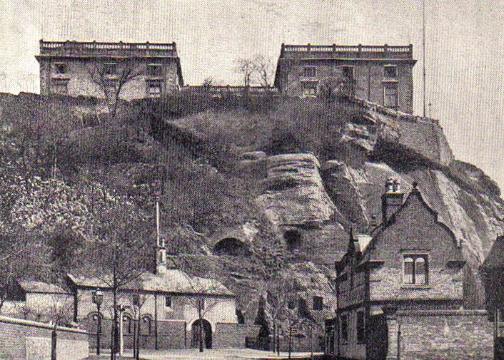
Here’s the terrace and a very poor view of the view:

The description continues with particular reference to individual streets, using the peculiar way of writing them as “Downing-street” for example. Many of them are no longer there in their ancient form, such as Arkwright-street and Kirke White-street. We only have the fossilised fragments of what they once were: `
“The Queen’s-walk was rendered impassable, and many of the houses on the sides had at least six feet of water in them. In parts of Queen’s-road, Arkwright-street, and Kirke White-street people were conveyed to and fro in carts. The water stood in the cellars of many of the houses in Leen-side, Carrington-street, Greyfriars-gate, and several other streets.”
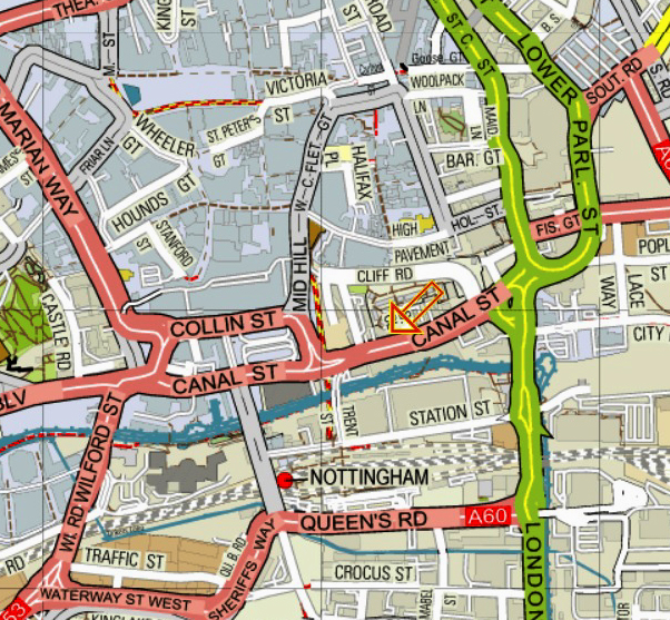
Let’s take a look at these more obscure Nottingham streets, because if a magic wand could be waved and they were reinstated, quite a few of Nottingham’s current traffic problems might be solved.
On the map below the orange arrow points to Queen’s Walk which I think is where the Manchester United footballer Andrew Cole originally came from. Queen’s Road, mentioned in the account of the flooding, is north east of the orange arrow and runs down the side of the station. Looking at the map, Queen’s Walk, still in white right next to the orange arrow, used to be a splendidly direct route out of the city to the south. Alas, it is now pedestrianized:
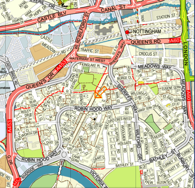
In the map below, Arkwright-street used to be a very big and important thoroughfare. It ran south of the station and curved gently but directly to Trent Bridge. It is there nowadays in a similar fossilised form. Find the red dot that marks the station at the top of the map below and follow it south eastwards towards the river in a long, long curve past the orange arrow and across to Trent Bridge, with the road number A60 on it. Nowadays, alas, this is not a continuous route for cars:

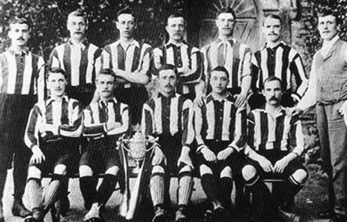
Kirke White-street was equally important. It ran from the canal on London Road straight as an (orange) arrow until it reached Wilford Road in the west. Kirke White-street crossed right through The Meadows, which were some of the most impressive slums in the whole British Empire. Even in 1970, children could be seen barefoot here, In the 19th century, its inhabitants provided the huge crowds that kept Notts County in the First Division and helped them to win the FA Cup:
After World War Two the inhabitants of the Meadows were moved en masse to Clifton Estate, some three or four miles outside the City.
Kirke White-street was a much used east to west route across the city and then out via Wilford Street and Wilford Road to Birmingham and the south west. On the map below, the long lost fossilised path of Kirke White-street is very roughly the red dotted line going east to west. Wilford Street and then Wilford Road is in the top left corner. It very quickly changes into the A453 which was the old main road to Birmingham:

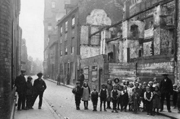
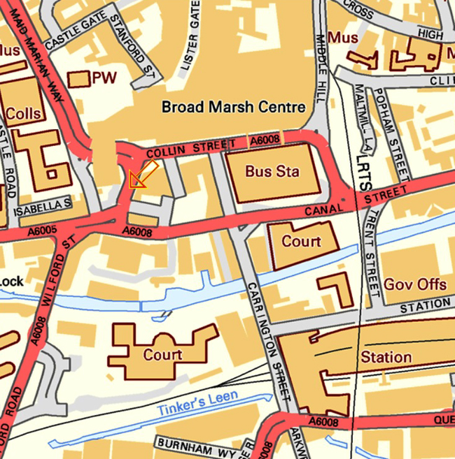
Leen-side is the eastwards continuation of Canal-street to London Road where the BBC is now situated. It ran to the south of Narrow Marsh, where the Nottingham police never dared to go. It was an area generally reckoned to be the absolute very worst slums in the whole British Empire. People who lived there used to queue up to live in the old Meadows. I found a picture of them queuing on the Internet. It’s hard to believe that on the right that group is just one family, but that’s what slums are all about:
Here is Leen-side, marked with the orange arrow. Just to the north of Canal Street, it used to form an excellent east-west route through the city, and linked well with the route leading south via London Road and the other one going past the red dot of the modern station:
Carrington-street was exactly where it is now and you can see it to the west of the railway station on the map below. In Victorian times, though, it ran a lot further north to a junction with Greyfriars Gate and Broad Marsh, much of which is now covered by the Broad Marsh Centre. Only a small part of Greyfriars Gate remains, between Wilford Street and the Broadmarsh Shopping Centre. I suspect that it used to link up with Lister Gate. I have marked it with our old friend, the Orange Arrow:
There will be more pointed accusations of the slack jawed local planners of the 1960s, and their pathetic and repeated failures to use their brains next time, although I do promise not to mention the fact that they demolished this wonderful old coaching inn and World War II RAF knocking shop without hesitation:

They replaced it with one of the finest examples of sixties architecture in the city:


The flood is particularly interesting to me. I don’t know the dates, but my late wife Jessica grew up with Napoleonic brandy and many unknown fine wines on the dinner table, because her grandfather’s wines had been kept in the caves under the castle, where a flood had soaked off all the labels. Was that the flood, I wonder?
It could well have been, but there were other floods in Nottingham during the century, with the worst in 1852 and 1875. It may depend too, on the date of Napoleon brandy which seems a little indeterminate:
https://en.wikipedia.org/wiki/Courvoisier
Still, it’s a very good anecdote, and I would certainly stick to it personally!
Thanks very much, John. The link led me to further speculation – one of Jessica’s ancestors was Napoleon’s surgeon on St Helena where he took a couple of barrels – the family have a photograph of a death mask
Interesting. I grew up with that vision of the beautiful Black Boy hotel. 1960’s architecture was the crime of the century, tearing down such beautiful iconic buildings. The saddest thing is my own Dad was a civil engineer and he was an instrumental part of the new replacement architecture that hit the city. Not that particular building though… 😥
Apparently, people actually wept in the streets as the first blows of demolition were struck.
The sixties were the era of the architecture criminals, with, in one instance, in another city, an entire hundred yard long medieval street being torn down to build the steps up to the shiny new “Eagle Centre”. So Nottingham was not the only city plagued by educated vandals.
One of your very best blogs, John. The “Date Book…” never disappoints. The Quorn Hash House Harriers, who deserve their own appraisal in time, occasionally run around some of those old streets in the Meadows. The incentive to move quite quickly through the area is still strong.
Having experience as Medders lad from Lamcote Street (well for my first few years) and having tentatively walked through fairly recently I would assert that the Meadows (best diction now) of today is a far more challenging place to be than in the 1960s…and, I don’t remember any of my contemporaries without shoes. It may be I’m seeing my time there through rose-tinted specs, but to me it was a really friendly community. Great blog though, is the level of the flood marked on the wall next to Trent Bridge?
Yes, it is, and there is a photograph of it in my blog post “More and more water, most of it under Trent Bridge (1)”. The stories about children without shoes come from John Hayes who has told me of it on more than one occasion. It may have been either Mr Hayes or the internet site “nottstalgia” which also told tales of kids being squeezed up on benches in the cinema on Saturday mornings, in the same way as the Tokyo underground operates now.
We used to live in the modern Meadows in the early 1980s and it was OK although in the years after we left, burglaries in the privately owned houses became more and more frequent. We used to shop in the precinct which is now famous for the drug telephone, but again, in the early 1980s, it was a perfectly safe place. I’m sure that nowadays it wouldn’t be. It was about six years ago when the French assistante and her boyfriend were accosted in St Ann’s and given a stern telling off for wearing the wrong gang colours and I suspect that that would be the case in the Meadows too.
Thanks very much for those kind words. We used to live in one of the new the new houses in the Meadows when they were first being built. The Robin Hood Marathon used to come past the end of our road, and we always did wonder why they were running so fast so near to the finish.
My father lived briefly in Lenton – not that far away – around 1950 and said that another boy on the street couldn’t go to school because he had no shoes. Whether it was prevalent or not I can’t say, but there is truth to it.
Great research, as I always find here! I can’t believe they knocked down that glorious Black Boy Hotel and put up that concrete/glass monstrosity. (But I suppose that;s all a matter of taste, eh?)
The sixties were an era of extreme vandalism in Nottingham as they were in many places in England. As I mentioned above, in one other city, an entire hundred yard long medieval street was torn down to build the steps up to the shiny new “Eagle Centre”. I suppose it was probably even worse in countries such as the USA or Australia where many of the very oldest buildings were made of wood and were therefore, so much easier to demolish.
Of course, we definitely went through that stage of get rid of the old and put parking lots and ‘chrome ‘n’ glass’ building up! It broke my heart.
John, do you know what caused the flood? Could it happen again?
I think it must have been extreme weather in the Pennine Hills where the River Trent has its source.
I don’t think it could happen again unless the weather goes completely crazy, because the city council took so many measures in the decades after the March 1947 flood, when melting snow and heavy rain produced an extreme flood situation. The city is now protected by twenty foot high concrete steps which prevent the floodwater from causing any damage to houses.
This, and other measures, is mentioned towards the end of my previous post, “Water, water everywhere, especially past Trent Bridge”, which has pictures of the concrete sluices used to hold back the floodwater when necessary. The floodwater is then released and floods the places it is supposed to, as the very last photograph shows very well.
The Black Boy was one of idiosyncratic Nottingham architect Watson Fothergill’s (Christened Fothergill Watson) best known buildings. Sadly its magnificent facade concealed a hotel building that would have been impossible bring up to the – relatively modest – modern standards of the 1960s, so its fate was sealed, and we got a new Littlewood’s instead.
It is an excuse of the time that they could not keep the outer structure of the building. Nowadays, every effort is made to save the outer shell of iconic historical buildings. The 1960’s were a time of tearing down much more solid buildings (even in the meadows) to replace them with inferior quality structures. It was the mandate of a generation determined to move into a space age, away from the era’s that had brought on two world wars. The movement to replace everything with ‘square untilitarian boxes’ was socialistic in nature… A world for equal opportunity taken away from the rich. Unfortunately, the results cast people en masse into a world of mediocrity when it manifested in the places that we lived and worked. My father worked on the revamp of Lloyd’s Bank in the Square. Beautiful mahogany woods were torn out and replaced with concrete and formica surfaces. I cannot think of a more catastrophic update than that.
To be honest, I find it difficult to believe that a Watson Fothergill building would be falling to pieces as there are so many left across Nottingham . One WF building is only fifty yards or so from the site of the Black Boy and that is still going strong. Watson Fothergill was such a fanatic for building standards, always carrying a dentist’s mirror
My own belief is that the demolition of the Black Boy was down to the curse of the later sixties, namely architects convinced that they were always right but capable of producing only the most appalling of unimaginative buildings such as Littlewoods, the Victoria Centre, the Broad marsh Centre and so on.
Other cities in England had even worse stories to tell.
I’m tempted do copy you and run a few old Ballarat buildings. But then, Ballarat was a tent village in 1850 so it’s only been going for less than 150 years.1
I would be pleased to see your photographs of old Ballarat. Don’t forget that everything is unknown to your readers outside Australia and is therefore interesting.
Never forget that “Soviet Bus Stops” now has a second volume. How interesting can a Russian bus stop compared to old horse racing track at Ballarat, or the local knocking shop(s) ?
The Midland Railway’s much grander and larger St Pancras Hotel was built around the same time as The Black Boy. Yet the LMS closed it in 1935 because the facilities were out-of-date and modernization was uneconomic.
The Black Boy’s bad luck was to not be as high profile as St Pancras and with Sir John Betjeman campaigning for its survival.
Was there such a thing as a listed building in 1935? I have no idea, but if there was no such scheme in operation it would have been only too easy to have made some spurious excuses and then to have got rid of any building in he way of the March to the Altar of the Great God, Greed..
Nottingham, like many cities, has changed dramatically over the years. I suppose the 60s were a boom time for removing the remaining slums of the Victorian era that Hitler had failed to remove for us. The problem was, as you have many a time stated, that what went up was lifeless and lacklustre to say the least. Cheap new materials that would create new housing and shops at minimal cost – not always the best solution to huge problems. A fascinating trip through time John thank you!
My pleasure! One ironic detail is that the prefabs in one particular Nottingham council estate, put up within months of Attlee’s government being voted into office, are still in existence and the inhabitants have fought tooth and nail to keep them, because they absolutely adore them. They may well have been one of the great number of prefabs sent over here from Sweden, all manufactured by a Swedish company, name of IKEA. I wonder what happened to them?
I wonder!