
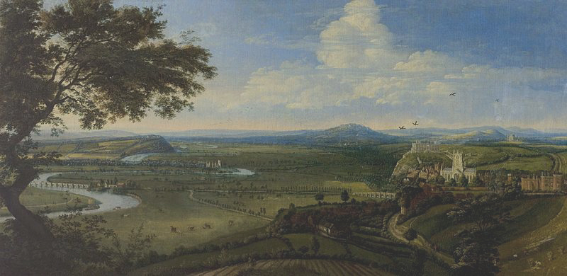
Recently, I wrote about the Great Flood of 1875, described by a person standing on the terrace at Nottingham Castle, looking across the valley of the River Trent. Here is an old oil painting of old Nottingham. It shows beautifully the castle on its cliff and, just in front of it, a brightly shining St Mary’s Church. You can also see the River Trent and the old Trent Bridge, just to the right of the tree trunk.
In 1499 Richard Mellers, the husband of Dame Agnes Mellers, founder of the High School, is known to have given twenty shillings to help repair this particular bridge which I believe was known back then as “The Bridge of Hethbeth”, although I’m not 100% certain of that.
In the centre of the picture, fairly distant, is the church at Wilford:
Last time I couldn’t stop myself looking at the streets of old Nottingham and how, in modern times, they have either disappeared, or have been made to disappear. I suppose really I was asking myself the question: “Would our journeys today be better if we could follow the same routes as Victorian roads did?
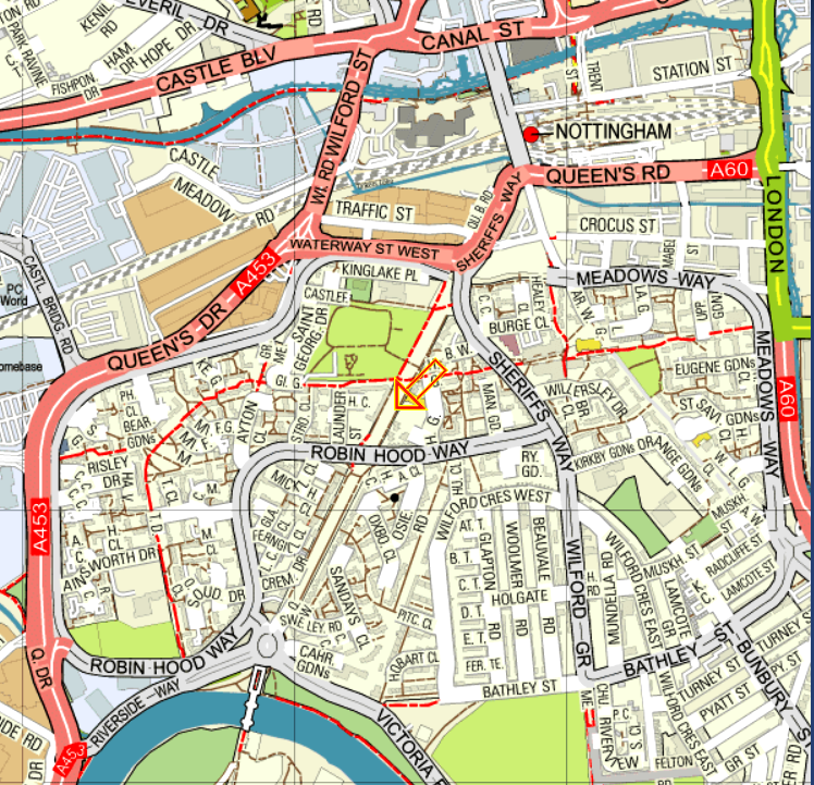
Here is one of the maps from last time. The orange arrow points to a thoroughfare no longer within our use. By a carefully planned coincidence, it is the road barely seen on the old oil painting of old Nottingham above, leading to distant Wilford Church (centre). The diagonal, all white, thoroughfare on the map, if continued to the north eastern, top right corner, would arrive at St Mary’s Church. In the other direction, that same straight road stretches southwards, straight as a die, to the River Trent and the Toll Bridge at Wilford on the left hand side. On the Ordnance Survey map, that very same route is highlighted by our trusty friend, the orange arrow. Nowadays, it would make a marvellous road into the city, especially for bicycles and even electric cars.
Personally, I do wonder if 130% of our traffic problems are down to planners who have completely disregarded those old streets which used to run, straight and wide, from one side of the city to the other. The worst obstruction to traffic flow in this area is the Broadmarsh Centre, a huge shopping mall which blocks so many of the old medieval and Victorian thoroughfares:
I do apologise for his absence, incidentally, but the orange arrow is currently on strike for better pay and more beautiful places to point to. Here is the 1970s car park for what was then the new shopping centre. It takes seven years or so to get a degree in architecture:
I had almost forgotten that I was writing about the Great Flood of 1875 as well as traffic flow. Well, nothing, including the Broadmarsh Centre if it had been there, could have stopped the vast floods of water from cascading through the city of Nottingham:
Wilford-road was the scene of a sad disaster, involving the loss of several lives. The flood was so deep that the only means of communication with Briar-street and the houses near it was by boats or vehicles; in the evening a man with a cart got about a dozen people into it in order to take them to places of less danger. They got out of Briar-street on to Wilford-road safely; but the posts on the road side being covered and only the street lamps to guide the driver, he got too near the edge of the road, which had been raised considerably, the cart was upset into the field on the east side, and six of the passengers were drowned. Next morning a man named Asher rode into the flood in the same neighbourhood in order to bring off a horse which was in an outlying shed, but was himself carried away and drowned. At Wilford the river overflowed the banks, washing down some of the cottages, and standing eight feet deep in many of the houses The traffic on the railway was much hindered, the trains from Trent having to be sent by the Derby, Codnor Park, and Mansfield lines.
Briar-street does not seem to exist any more. Wilford Road is the eventual continuation of Wilford Street towards the top left/centre of the map. It used to run southwards straight as an orange arrow to Wilford Ferry Bridge, at the bottom of the map. Most of that direct route is no longer there or is no longer usable. It has been interrupted, mostly by housing and parts of Robin Hood Way and Sheriff’s Way:

We already know Wilford and its famous ferry, replaced eventually by a bridge:

The Kannibal Killer Kaptain John Deane used to live just the other side of the bridge from Nottingham:

This was definitely THE flood in Nottingham. As the book says:
“This flood of 1875 was 5½ inches higher than that of 1852, 23½ inches higher than the floods of 1869 and July, 1875, 28 inches higher than the flood of January, 1877, 36 inches higher than the Floods of 1857 and 1872, and 39 inches higher than that of 1864”
The heights of those floods are recorded underneath present day Trent Bridge:


I have always thought that Nottingham is a wonderful example of poor urban planning!
I think that in recent years I would agree with you. By 1939, the city had an incomplete but functionning inner and outer ring road, but after that it was the usual thing of “Forget the pedestrian, go for the four lane option”, without regard for where that high speed road might be,
And judging by what stands nowadays next to Maid Marian Way, for example, a four lane road just to west of the city centre, a lot of old buildings must have been knocked down, as well as the Black Boy Hotel.
Some flood, John. I remember the Broadmarsh Centre as an unsightly nightmare
Absolutely. At the moment it is being revamped at great expense and if you google it, you can see what an earthly paradise is being prepared for us all. All it lacks is Jesus himself walking across the water of the atrium fountain, but I bet that they are working on it.
Money well spent – Not
Brother do you have your troubles – Arrow is on strike; a man dies trying to save his horse, a cannibal killer nearby and a huge flood!!
You cannot fault Nottingham for excitement, although it should be pointed out that we don’t experience all of these things at once. My big event of recent times was last month, when I went to a service to commemorate the foundation of the school. Afterwards, there was a cheese and wine lunch and I got to meet the Sheriff. The actual Sheriff of Nottingham, whose job still exists after all these years! Even at my age, it was a real thrill.
The modern Sheriff is a woman. Presumably, they are trying a different approach to get Erroll Flynn back in his dungeon.
I had heard years ago that the job of Sheriff still existed – I thought that was OUTSTANDING!!
I’m terribly sorry; I’m trying to ‘like’ your post, but it is not allowing me to do so. Nevertheless, again, thank you for your tremendous blog!
That’s OK. Don’t worry about it. As long as you spend some of your time reading it, I am totally happy.
I enjoy your posts, very much!
John, Queen’s Walk is now used by the tram line from Clifton, via the old Wilford Toll Bridge to the city centre. It is still an excellent cycle route.
Thanks very much for that. I haven’t been down there for quite a few years but I suppose it is proof that Queen’s Walk and Wilford Toll Bridge are still capable of moving people in and out of the city.
I suppose that the basic point I am making is “Don’t be too quick to demolish and to change”. Have a think about what could be done to solve problems in a subtle way. And in this case, it has worked for the new tramline and for cycle users.
I wish the north and east of the city was a little bit flatter. That would make it a lot easier for people to use cycles, and people who are perhaps a little less fit could give it a go.
John, Nottingham’s road system is a post all of its own. The city fathers’ investment in the Western ring road during the 1920s was remarkably prescient, as the specification (such as sufficiently wide bridges) was way ahead of the traffic volumes of the time. It also led to oddities such as the Wilkinson Street “stub” which was enormously wide but led nowhere.
As for the ugliest street in Europe (Maid Marion Way) that came into being when Nottingham’s urban motorway was cancelled in the late 60s.
The Sheriff’s Way was to have encircled inner Nottingham and the proposed route , which included the obliteration of Forest Road, might have prompted a rethink of earlier plans for the relocation of NHS to Valley Road.
Maybe if he Broadmarsh had been there, the floods would have washed it away and allowed Victorian planners to produce something better than those with their seven year degrees!
There was a Broad Marsh, but it wasn’t a shopping centre but an area of Victorian slums. If you go here:
https://www.nottinghampost.com/news/history/see-early-photographs-nottinghams-broadmarsh-1558044 and scroll down, there is one single picture that captures the “flavour” of the place.
Before that, as the name suggests, the River Trent was part of a huge complex of shallow pools and marshes. When the Broadmarsh Centre was built, archaeologists found stone age hunting equipment such as stone axes and arrow heads. These were positioned such that we know that the modern rear entrance to the centre, and the escalators below it, follow what appears to be a stone age hunting track, used tens of thousands of years ago
How interesting John. The picture certainly does give a flavour of what it was like and some of those stories are fascinating in themselves. Thank you for the link.
I concur absolutely with your thesis. I have yet to find a traffic planning scheme which actually improves traffic flow. What were once the bustling streets of cities lined with independent shops have been smothered by concrete monstrosities which look as if they were built to the instruction of Josef Stalin. Here in Bristol the council’s every new traffic scheme makes the congestion worse. We also have ‘The Mall’ at Cribb’s Causeway, a temple to ostentatious consumption whose car-park seemingly covers an area the size of Rutland.
In retrospect, I wouldn’t have minded studying traffic flow. Apparently, it follows the same rules as floodwater and any attempts by the police to direct it and improve the flow always end up with a worse situation than if all the officers had kept out of it.
I think that Nottingham is making perhaps its last attempt to attract people away from IKEA and all of the other wonderful shops in the retail park next to the motorway at Ilkeston. They are also fighting a losing battle with Amazon who, surprise, surprise, find it advantageous to operate without paying any tax. Apparently, Mr Amazon pays less tax than the ordinary American OAP.
Perhaps a very brave council should try opening a centre, right in the middle of the city, to give little businesses a chance. Home made soap, home made sauces and so on. They could also have a performing arts centre and a concert hall, but all on a local level.
“Local shops for local people” as the saying goes.
John, there is an interesting (well it depends on your POV!) discussion (with maps) of Nottingham’s erstwhile urban motorway plans right here.
https://www.sabre-roads.org.uk/forum/viewtopic.php?t=18761
The Arboretum and, presumably, the NHS would have been buried under a mini Spaghetti Junction.
Thanks a lot for that. It’s very interesting but possibly more scary than interesting. I dread to think what Nottingham would have looked like if these plans had been pursued. Maid Marian Way is bad enough.
It’s interesting too how these planners seem to have had no idea of what would be needed in forty or fifty years’ time, although, to be fair, the fact that the idea never came to fruition, may indicate that somebody had a little bit of common sense.
Used to live on Aber Terraces off Briar Street and went to the High School.
Thanks a lot for your interest. Briar Street was one of the many streets demolished when the Meadows were rebuilt, if my memory serves me well. You might enjoy the Facebook group “Nottingham Way Back When..” and the website “https://nottstalgia.com/forums/” Nottstalgia also have a facebook group.