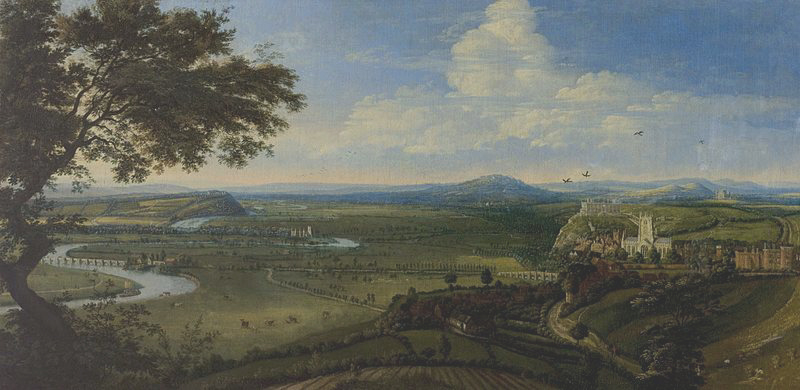
Recently, I wrote about the Great Flood of 1875, described by a person standing on the terrace at Nottingham Castle, looking across the valley of the River Trent. Here is an old oil painting of old Nottingham. It shows beautifully the castle on its cliff and, just in front of it, a brightly shining St Mary’s Church. You can also see the River Trent and the old Trent Bridge, just to the right of the tree trunk.
In 1499 Richard Mellers, the husband of Dame Agnes Mellers, founder of the High School, is known to have given twenty shillings to help repair this particular bridge which I believe was known back then as “The Bridge of Hethbeth”, although I’m not 100% certain of that.
In the centre of the picture, fairly distant, is the church at Wilford:
Last time I couldn’t stop myself looking at the streets of old Nottingham and how, in modern times, they have either disappeared, or have been made to disappear. I suppose really I was asking myself the question: “Would our journeys today be better if we could follow the same routes as Victorian roads did?
Here is one of the maps from last time. The orange arrow points to a thoroughfare no longer within our use. By a carefully planned coincidence, it is the road barely seen on the old oil painting of old Nottingham above, leading to distant Wilford Church (centre). The diagonal, all white, thoroughfare on the map, if continued to the north eastern, top right corner, would arrive at St Mary’s Church. In the other direction, that same straight road stretches southwards, straight as a die, to the River Trent and the Toll Bridge at Wilford on the left hand side. On the Ordnance Survey map, that very same route is highlighted by our trusty friend, the orange arrow. Nowadays, it would make a marvellous road into the city, especially for bicycles and even electric cars.
Personally, I do wonder if 130% of our traffic problems are down to planners who have completely disregarded those old streets which used to run, straight and wide, from one side of the city to the other. The worst obstruction to traffic flow in this area is the Broadmarsh Centre, a huge shopping mall which blocks so many of the old medieval and Victorian thoroughfares:
I do apologise for his absence, incidentally, but the orange arrow is currently on strike for better pay and more beautiful places to point to. Here is the 1970s car park for what was then the new shopping centre. It takes seven years or so to get a degree in architecture:
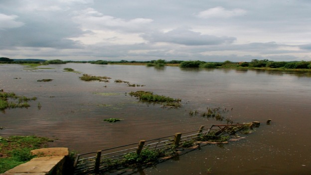
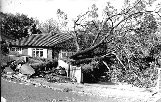
I had almost forgotten that I was writing about the Great Flood of 1875 as well as traffic flow. Well, nothing, including the Broadmarsh Centre if it had been there, could have stopped the vast floods of water from cascading through the city of Nottingham:
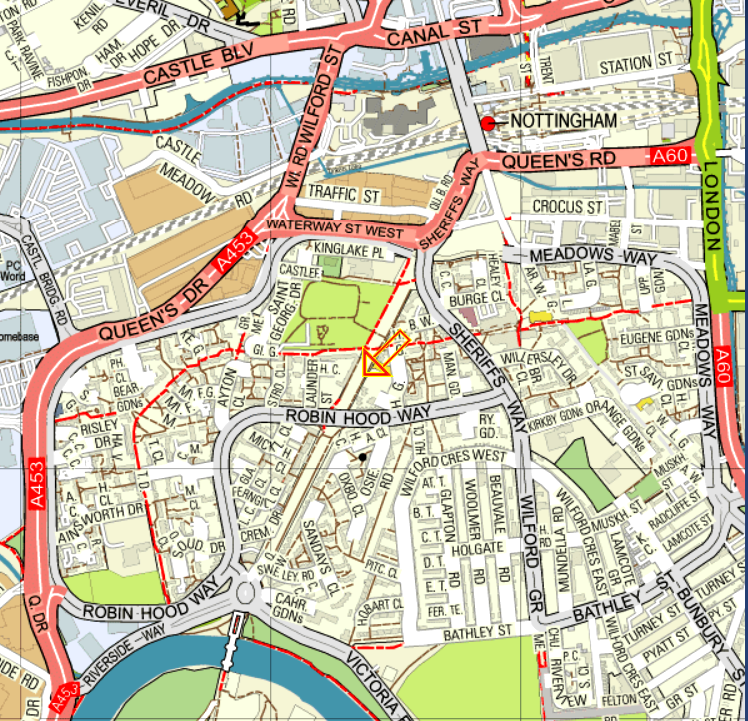
Wilford-road was the scene of a sad disaster, involving the loss of several lives. The flood was so deep that the only means of communication with Briar-street and the houses near it was by boats or vehicles; in the evening a man with a cart got about a dozen people into it in order to take them to places of less danger. They got out of Briar-street on to Wilford-road safely; but the posts on the road side being covered and only the street lamps to guide the driver, he got too near the edge of the road, which had been raised considerably, the cart was upset into the field on the east side, and six of the passengers were drowned. Next morning a man named Asher rode into the flood in the same neighbourhood in order to bring off a horse which was in an outlying shed, but was himself carried away and drowned. At Wilford the river overflowed the banks, washing down some of the cottages, and standing eight feet deep in many of the houses The traffic on the railway was much hindered, the trains from Trent having to be sent by the Derby, Codnor Park, and Mansfield lines.
Briar-street does not seem to exist any more. Wilford Road is the eventual continuation of Wilford Street towards the top left/centre of the map. It used to run southwards straight as an orange arrow to Wilford Ferry Bridge, at the bottom of the map. Most of that direct route is no longer there or is no longer usable. It has been interrupted, mostly by housing and parts of Robin Hood Way and Sheriff’s Way:
We already know Wilford and its famous ferry, replaced eventually by a bridge:
This was definitely THE flood in Nottingham. As the book says:
“This flood of 1875 was 5½ inches higher than that of 1852, 23½ inches higher than the floods of 1869 and July, 1875, 28 inches higher than the flood of January, 1877, 36 inches higher than the Floods of 1857 and 1872, and 39 inches higher than that of 1864”
The heights of those floods are recorded underneath present day Trent Bridge:
As you may already know, I am really head over heels with “The Date-Book of Remarkable Memorable Events Connected With Nottingham and Its Neighbourhood 1750-1879”, by John Frost Sutton. It records a world so similar and yet so different to our own. Fire, for example, was a very great concern when so many buildings were made of wood and the fire brigade arrived behind four horses.
First though, a couple of words of introduction. This is a bonnet front:
And so is this:
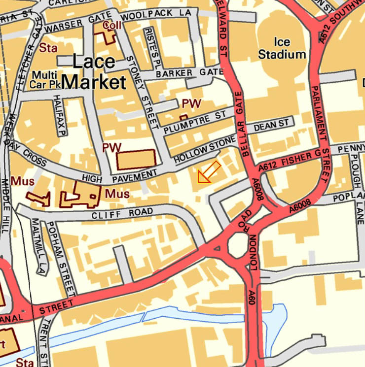
And this is Commerce Square, in the Lace Market area of the city. The letters “PW” indicate a “place of worship”, in this case, St Mary’s Church. The orange arrow indicates the exact location of the warehouse:
“October 11 1866
“Destruction by fire of the bonnet front warehouse of Mr. C. G. Hill, Commerce-square.”
“It appears that Mr Hill kept a large quantity of pigeons at the top of his warehouse and that after the workmen had left in the evening, he and some men went upstairs on some business to do with the birds.”
“While he was there Mr. Hill was surprised at a loud knocking at the warehouse door, and on going to the top of the stairs, he found that the lower portion of the premises was in flames, and that leaving by the stairs was impossible. Fortunately there was a trap door in the roof, through which they made their escape. The fire leaped upwards with fearful rapidity from floor to floor, and soon enveloped the whole of Mr. Hill’s premises in a glowing sheet of flame, which burst with great fury from the windows, lighting up a vast area, and presenting a spectacle of grandeur, particularly when viewed from the southern side of the town, which it overlooks”:
“It was at one time feared that the burning building would fall into Narrow-marsh, and many of the inhabitants removed their goods, but beyond some falling pieces of burning timber, the massive roof of the building remained nearly intact. The interior, though, was completely burnt out, with nothing remaining but the shell. This building is eight stories high on the southern side. As the lower four stories in Narrow-marsh were occupied as houses, a fire-proof floor was inserted between the houses and the warehouse. This prevented the fire extending to the lower portions of the building, although they and their contents were much damaged by water. It was estimated that Mr. Hill’s stock was worth £10,000, he having from 10,000 to 15,000 boxes of bonnet fronts on hand. He was insured for £8,000, and the building, including the warehouses of Messrs. Hamel & Wright and Lottimer & Co, for £9,000. After Mr. Hill’s escape from the roof he climbed down into the building and turned off the gas, making his way out through the cellar grate.”
If Mr. Hill’s stock was worth £10,000, in today’s figures, that would be in the region of £1,140,000 nowadays. His insurance would have covered £912,000 by today’s reckoning, with the insurance on the warehouses of Messrs. Hamel & Wright and Lottimer & Co realising £1,026,000. Sounds like a job for Columbo to me:
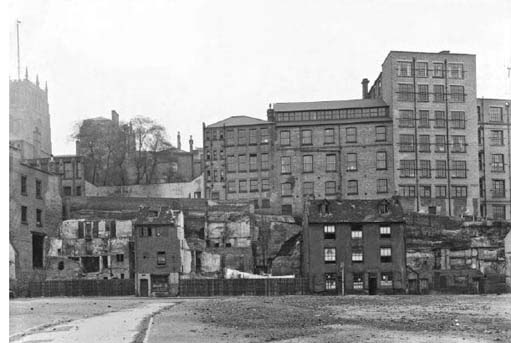
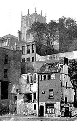
Narrow Marsh, the area below the Lace Market area, with, originally, a sandstone cliff at its back, was notorious in Victorian times as containing the worst slums in the British Empire, bar none, and being a place where only a mad policeman would attempt to go.
This photograph shows the many, many floors of some of the buildings, constructed against the cliff face itself:
Here is a very ‘film noir’ shot of the streets below the cliff:
And, at last, the slums are torn down in the 1950s:
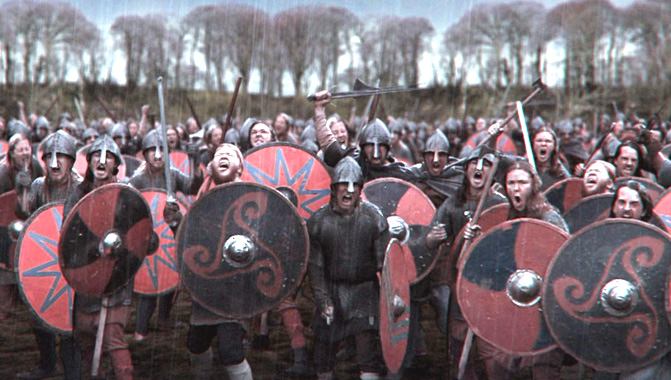
Last time, I left you awaiting the arrival of Ragnar Lothbrok and his rather fierce friends in Anglo-Saxon Nottingham.
Well, by 867, Anglo-Saxon Nottingham had been well and truly captured by the Vikings and it became one of the Five Boroughs of the Danelaw. There may have been little in the way of extreme weather in this era, but their names were fabulous. The Five Boroughs of the Danelaw is a striking enough phrase, but the name of the army which made Snotingaham, at sword point, an offer they could not refuse, is, quite simply, wonderful. A thousand years before Heavy Metal bands, they rejoiced in the name of “The Great Heathen Army“. And here they are. They’re really quite handsome, aren’t they?
Then again, I really don’t see them as a group of people capable of waiting quietly for a bus: Another episode of extreme weather on the rain front came in 1141 when there was another Great Flood. And once again, the flooding was caused, as in 1947, by the mechanism of a sudden melt of large quantities of snow after prodigious amounts of rain. People in 1141 looked like this. Around this time there was clearly a significant risk for everybody of just rusting solid into one great mass:
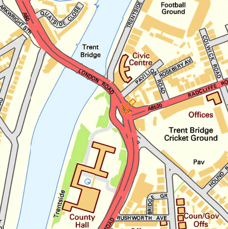
In 1309, Hethbeth Bridge, the medieval precursor of today’s Trent Bridge, was washed away by severe winter floods. A small fragment of this old bridge is still visible on the road island at the southern end of the modern Trent Bridge: If you go to see it, be very careful. Traffic nowadays is much more dangerous than “The Great Heathen Army”. Look for the orange arrow:
In 1346, little detail has come down to us, other than:
“from mid-summer to Christmas, the rains fell almost without intermission”.
The River Trent duly experienced:
“One of the earliest recorded floods.”
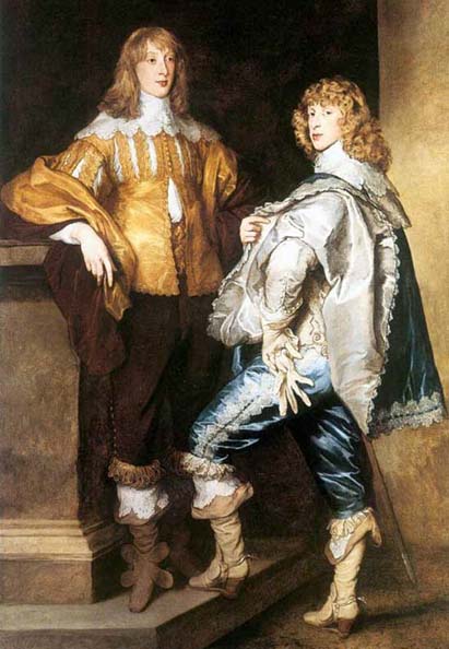
In 1499 Richard Mellers, the husband of Dame Agnes Mellers, of High School fame, is known to have given twenty shillings to help repair one of an apparent succession of Hethbeth Bridges, but it was pretty much in vain, as the Great Flood of 1683 washed a good proportion of it away. Here are two men in 1683. That’s not a look you can just throw together:
The worst ever flood in Nottingham was the so-called “Candlemas Flood” of February 1795, when two months of continuous ice and snow all melted extremely rapidly. Every single bridge on the entire River Trent was either damaged or washed away, including the Hethbeth Bridge for the umpteenth time. In the Narrow Marsh area of the city, around what is nowadays Canal Street and the land to the south of St Mary’s Church, the residents were all trapped in the upstairs of their houses and had to be given food from boats. At Wilford, up to 100 sheep were drowned and ten cows perished in West Bridgford. That doesn’t sound much, but they only had twelve.
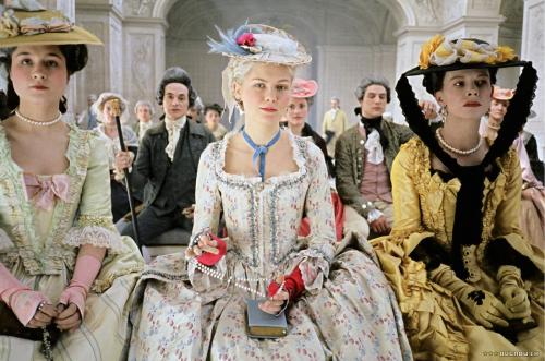
The late eighteenth century provided some wonderfully ornate dresses, all guaranteed to keep you afloat until help arrived:
Another less severe flood came in November 1852 when the peak flow of the Trent was measured at some 38,200 cubic feet per second, between twelve and thirteen times the normal levels. A second, slightly worse Victorian inundation came in October 1875 when floodwater was up to six feet deep. During this latter flood the peak flow of the Trent was 45,000 cubic feet per second, fifteen times the normal levels. On Wilford Road an overcrowded cart was washed away and six people were killed. Higher up the river, huge numbers of farm animals were drowned and they must have been a ghastly sight as they floated down to the sea past Trent Bridge:
In a previous article, I wrote about the flooding of Nottingham during the modern era, and the ways in which we have learnt lessons from the floods of 1947 and constructed concrete embankments and sluices so that the River Trent is nowadays, to all intents and purposes, relatively tame. (“relatively” being the operative word.) If you walk down to Trent Bridge and look underneath the bridge on the City side, directly beneath the Riverbank Bar and Kitchen, however, you will see how the flood levels of previous years of watery disaster have been recorded. They are scarily impressive and well worth a visit:
This slideshow requires JavaScript.
The very first records of floods in Nottingham are more a case of inference than anything else. According to the (Royal) Journal of the Statistical Society, Volume XLI and “The Insurance Cyclopaedia” by Cornelius Walford (I need to get out more):
“29 A.D. There was a great overflow of the River Trent in England”.
In 214 A.D. the entire River Trent was again in flood and overflowed its banks by some 20 miles on each side from the normal course of its flow. Many people were drowned as the whole Trent valley was awash and there was great destruction. Both of these dates are during the Roman era, although Nottingham was not, as far as I know, a Roman town. Perhaps they knew that an underlying band of hard rock could be used to ford the river and its adjacent marshes. Just to establish our dates firmly, here is a Roman. Like every single Roman, he is a legionnaire, although he doesn’t look particularly ill to me, but that hat is really something: In 525 A.D. the entire Trent again burst its banks and a great number of cattle were drowned. The locals at his time may well have been Celts since we know that Nottingham, in the Brythonic Celtic language was called “Tigguo Cobauc”, meaning “The Place of Caves”. The Welsh may have been aware of Nottingham’s existence since they called it “Y Ty Ogofog” and even the distant Irish had a word or two for it, namely “Na Tithe Uaimh”, “The Cavey Dwelling”. Here are some Celts, managing to appear very, very fierce indeed, although admittedly, there is more than a dash of Village People in the overall look, especially the one at the front who may have no clothes on at all: Whoever the locals were in 530 A.D., they would certainly have got extremely wet at some point. The mighty River Humber is known to have flooded extensively onto adjacent low-lying ground and most of the region’s cattle were drowned. Much of that excess of water, of course, was bound to have come from the River Trent, which feeds into the Humber. It is difficult to see how Nottingham, at the side of the River Trent, of course, could have escaped floods of such severity. It was slightly after this date that Nottingham, by now a small group of wooden huts and a line of washing, came under the sway of the wonderfully named “Snot”, an Anglo-Saxon chieftain. The place where “The Mighty Snot” lived was immediately called “Snotingaham”, the “home of the people of Snot the Magnificent”. At this time, “Snotingaham”, was part of the Kingdom of Elmet. Here is an Anglo-Saxon chief and his friend. What impressive elmets they are wearing:
I just couldn’t resist that!
Next time, we will see what happens when Ragnar Lothbrok and his pals arrive in Nottingham on a seven-day-cruise in 867AD.
In the first part of this article, I demonstrated how Richard Mellers, the husband of Dame Agnes, was, at best, a fairly unscrupulous businessman. I ended by relating how, in 1507, Richard had received a pardon for having committed offenses against the statutes of weights and measures. This charge related to problems with the purity of his bells. The metal, apparently, was just not as valuable as he said it was. Richard’s pardon would have been granted because of his previous position as Mayor of Nottingham. A less prestigious person would have been in very, very, serious trouble:
Dame Agnes, of course, may well have known absolutely nothing whatsoever about any of this rather serious matter. Like many, many husbands over the centuries, Richard may have decided, quite simply, to tell her nothing at all about it. And if she did know about her husband’s cheating and double dealing, then, like many, many wives over the centuries, she may perhaps have turned a blind eye to it, hoping that one day her errant husband would rejoin the forces of light.
He didn’t though. At least not for long, because on or about Sunday, June 16th 1507, Richard Mellers died, with the ink on the pardon if not still wet, then certainly recognisably damp. I think Dame Agnes would have seen his sudden demise as a direct consequence of his previous wrongdoing. She must have thought that her husband’s death so soon after receiving a pardon was the true verdict from on high.
In more modern, medical, terms, Richard may well just have hastened a natural death by continually feeling guilty or by worrying too much about the outcome of the affair. He may, quite simply, have been a victim of early sixteenth century stress. Irrespective of the clinical truth, though, for a devout woman in Tudor times, these events must have seemed like a clear judgement from Heaven.
At the beginning of the sixteenth century, it would have been completely impossible for a sincere and devout Roman Catholic to be in any conceivable way ignorant of the rôle played by Hell in the scheme of things. How can Dame Agnes have possibly thought back about her husband’s life, misdemeanours and sudden death, and not have seen him as the proud possessor of a “Go straight to Hell, Do not pass Go, Do not collect a ticket to Heaven” card?
That must have been a very, very real fear in her mind.
Here’s how the Rock Combo “AC/DC” saw the situation, firstly on an album cover:
And then on stage:
More or less straightway after his death, therefore, Dame Agnes, the grieving widow, became a “vowess”. She resolved never to remarry, and instead to devote herself to the service of the church.
“a woman who has vowed chastity or devotion to a religious life; a nun”.
Other dictionaries tell pretty much the same tale. One other interesting detail about vowesses is given in “The Customs of Old England” by F. J. Snell. Writing about how a vowess would view her obligations, he states that:
“Whatever fasts a vowess might neglect as non-obligatory, it seems probable that she would not willingly forgo any opportunity of showing reverence to the Blessed Virgin.”
More of this later.
Immediately after her husband’s death, Dame Agnes tried to repay many of his victims. She literally gave them back the exact sums of money which she was worried they had lost to her husband.
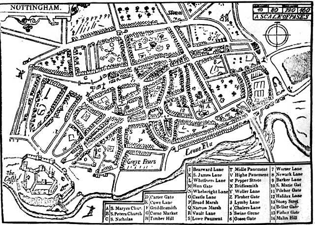
She then decided to spend the rest of Richard’s money on charitable causes. Most important of all, she decided to found a school. Or alternatively, she decided to fund a school which was already in existence and was clearly in need of financial assistance. She must have known that this one simple act would benefit the citizens of Nottingham in the long term, and make up for the occasions when, for short term gain, her late husband had cheated them. Here is the grateful city in 1610. St Mary’s church is marked with the letter “A”. Keep looking. It is there:
Before the official first day of her school, February 2nd 1513, there had already been eleven apparent references to a “Nottingham Grammar School” between 1289 and 1513. At this point in time, of course, it is impossible to tell what connection, if any, there is, with Dame Agnes’ school. Indeed, we do not even know if the eleven schools mentioned before 1513 have a continuous history, or whether they were all short lived affairs.
Having said that, though, Dame Agnes may well have decided to develop an ancient original grammar school into her own school. This original establishment may have depended solely on fees paid by the pupils. Dame Agnes perhaps thought it would be a good idea to establish a foundation, which would then ensure a much better financial future for the school. Equally, she may well have wished to take personal dcontrol of an older school, and then, as a loyal Catholic, to bring it under the control of St Mary’s Church.
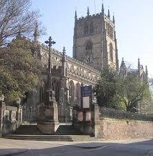
Whatever the details of founding, funding, refounding or whatever, from Dame Agnes’ point of view, the most important thing was that the school should remain closely linked to St Mary’s Church. This, of course, carries out the words of F. J. Snell. Her efforts with this school clearly showed that Dame Agnes would “not willingly forgo any opportunity of showing reverence to the Blessed Virgin”. Here is St Mary’s Church nowadays:
All this sounds like heresy now, of course, after a whole series of celebrations have commemorated the 500th Anniversary of the school, and books have been published, but these ideas are not actually mine own. In “The Nottinghamian” for 1924, for example, there was a clear connection stated in the school magazine between the older schools from before 1513 and the then Nottingham High School. Dr James Gow, the school’s greatest Headmaster, had died this particular year:
In his obituary, it was said that:
“he was appointed Headmaster of the Nottingham High School, an ancient Grammar School, already existing in the thirteenth century, and refounded and endowed by Dame Agnes Mellers, under a Charter of King Henry VIII, in 1513.”
These words are anonymous, but were most probably written by Mr “Sammy” Corner who had been the school’s Deputy Headmaster until his retirement in 1914. Mr Corner had spent much of his spare time researching school history and had become a great expert. Much of this knowledge was to appear in the school magazine which he edited for many years, and which at one point had contained a serialised history of the school. After his retirement, the plan was that Mr Corner would finish writing his history of the High School.
Alas, this popular member of staff was destined never to write his book, as the Great War broke out only a month after he was due to start work, and, despite his advanced age, Mr Corner went off to do his bit for the war effort. At the end of the conflict, Mr Corner moved from Nottingham to Croydon, but his life’s work was to remain forever uncompleted, a source of great regret, as he later told Mr Reynolds, the Headmaster, in a letter. This is the great Sammy Corner in 1913, showing off the school’s charter in the 400th anniversary celebrations in 1913:
On the afternoon of Monday, November 13th, 1933, similar ideas about the school’s history to those in Dr Gow’s obituary were being expressed by the Duke of Portland, when he performed the formal opening ceremony for two new High School buildings, the Gymnasium and the newly converted Library.
This very same interpretation was obviously still current around this time, when Mr.C.L.Reynolds, the Headmaster, wrote his own brief history of “The Buildings of Nottingham High School”. He described the events of 1513 as “…the re-foundation or endowment of the School by Dame Agnes Mellers.” Here is Mr Reynolds, seen with the prefects, in an unknown year, probably in the 1930s:
Furthermore, a document more contemporary to Dame Agnes’ time said that what Dame Agnes was doing was to “…unite, create and establishe a Free Scole” as if there were some definite connection between her school and the Nottingham schools of previous centuries. Similarly, she is referred to in a number of other early documents not as a “foundress” but as a “fundress”, as if she were building and strengthening what was already there.
How that fear of the “Go straight to Hell, Do not pass Go, Do not collect a ticket to Heaven” card must have haunted Dame Agnes. As well as her wonderful achievements with the school, she also laid down that a service of commemoration for her deceased husband should be held every year on June 16th. This latter date is thought to have been chosen because it was the Feast Day of St Richard of Gloucester. Interestingly enough, St Richard’s shrine in Chichester Cathedral, at this time, was a magnificently decorated and popular destination for the Tudor Pilgrim. Perhaps Dame Agnes had been there herself as a dedicated vowess:
The ceremony which Dame Agnes had requested was, of course, a solemn Roman Catholic mass for the soul of her dear departed husband. It is thought that this mass was probably celebrated for about thirty five years, until such services were abolished by order of the then king, Edward VI. This same type of mass may then possibly have been revived under the Catholic Queen Mary, but it certainly would have disappeared for ever when the Protestant Queen Elizabeth I came to the throne in 1558.
Even in the 1660s though, some hundred and fifty years after Dame Agnes, the students still went every Friday during the period of Lent, with their teachers, to visit St.Mary’s church, and kneel in front of the tombs of Richard and Agnes Mellers, and say prayers for their souls, and the souls of all their relatives. And even nowadays, every year on Founder’s Day, the congregation still says prayers for the souls of Dame Agnes, and more importantly perhaps, her husband, Richard. This is Founder’s Day in 1957, a beautiful backlit day:
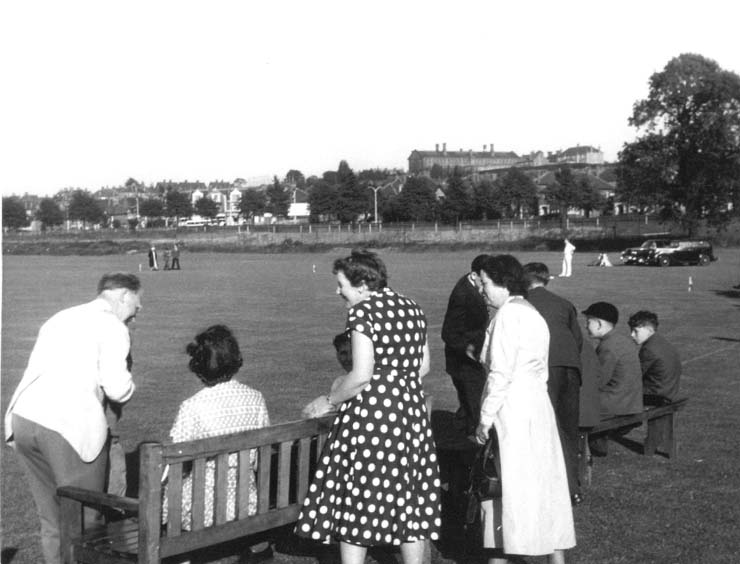
This is the Cheese and Ale Ceremony in the same year:
They’re going to get very drunk very quickly if they fill those tankards too frequently. Here is the traditional Cricket Match on that sunlit afternoon in 1957:
Having explored the history of the High School for more than twenty five years, I have always thought that the school’s beginnings are shrouded in mystery. For me, the High School has always been very like the Soviet Union:
“a riddle, wrapped in a mystery, inside an enigma”
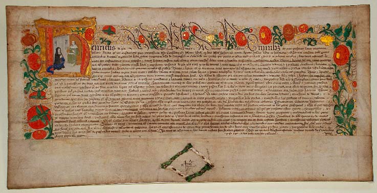
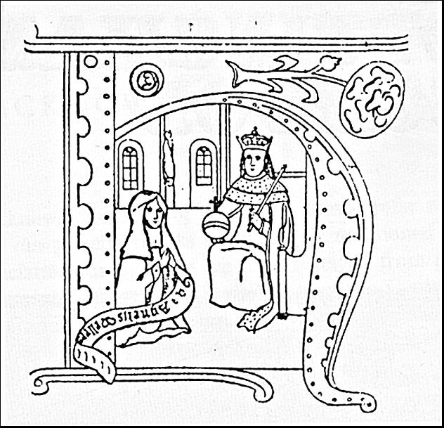
What do we know about the founder of the school, Dame Agnes Mellers, for example? What was she like as a person? There are a very few illustrations which are thought to be her. This is the school’s charter:
And here is a close-up of Dame Agnes and King Henry VIII:
This is the charter changed into a line drawing:
For me, there have always seemed to have been two enormously important motivating forces in her character. The first was her staunch religious faith as a Roman Catholic with a sincere love of Jesus Christ and the Catholic Church. Dame Agnes seems in many ways to have been an uncomplicated soul, who viewed the world in a simple direct way. She tried to be a good person, with the sincere belief that we should all try to make things better rather than worse, that we should do good things rather than evil and that we should always strive to be on the side of the Angels.
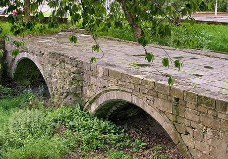
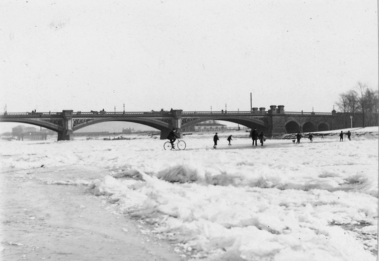
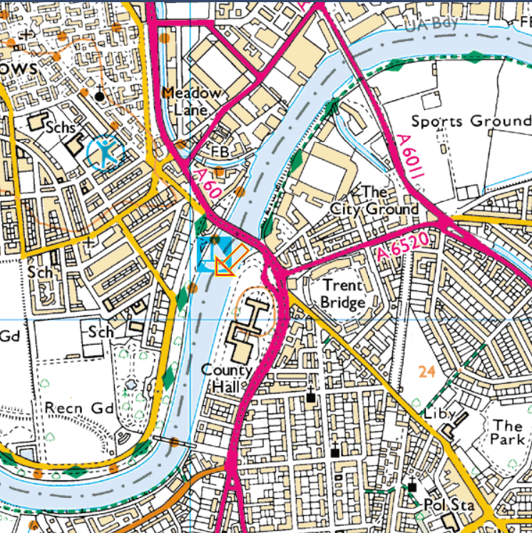
The second motivation for her was the love she had for her husband, Richard, which seems as sincere and unswerving as her love for the Church. Richard was, as his name suggests, a rich man. He was at one time or another, Sheriff of Nottingham (1472-1473), Chamberlain (1484-1485) and Royal Commissioner and Mayor of Nottingham (1499-1500 and again in 1506). In 1499, he is known to have given twenty shillings to help repair the Hethbeth Bridge, as Trent Bridge’s predecessor was called. Here is one of the last photographs ever taken of the old bridge before it was superseded by the present Trent Bridge. You can certainly see why it was easier for the river to freeze up in those days:
This is all that remains of the Hethbeth Bridge nowadays:
It is in the middle of a road island to the south of Trent Bridge. If you decide to take a look at it, be very careful of the traffic and use the proper crossings. Look for the (camouflaged) orange arrow in the centre of the (red) road junction:
Richard Mellers was a brazier, and probably a potter, and he had certainly dealt in metal pots and dishes. Most important of all, he owned the largest church bell-foundry in the region. The site of his premises has long disappeared, but its exact location is still known today.
From 1888 onwards, just a very few yards north of the city centre, steps began to clear away:
“a curious V-shaped slice of slum property…a most unhygienic and immoral neighbourhood and nothing good could be said for it”.
This slum clearance took a number of years, and resulted in the formation of King Street and Queen Street, the latter being opened on June 22nd, 1892.
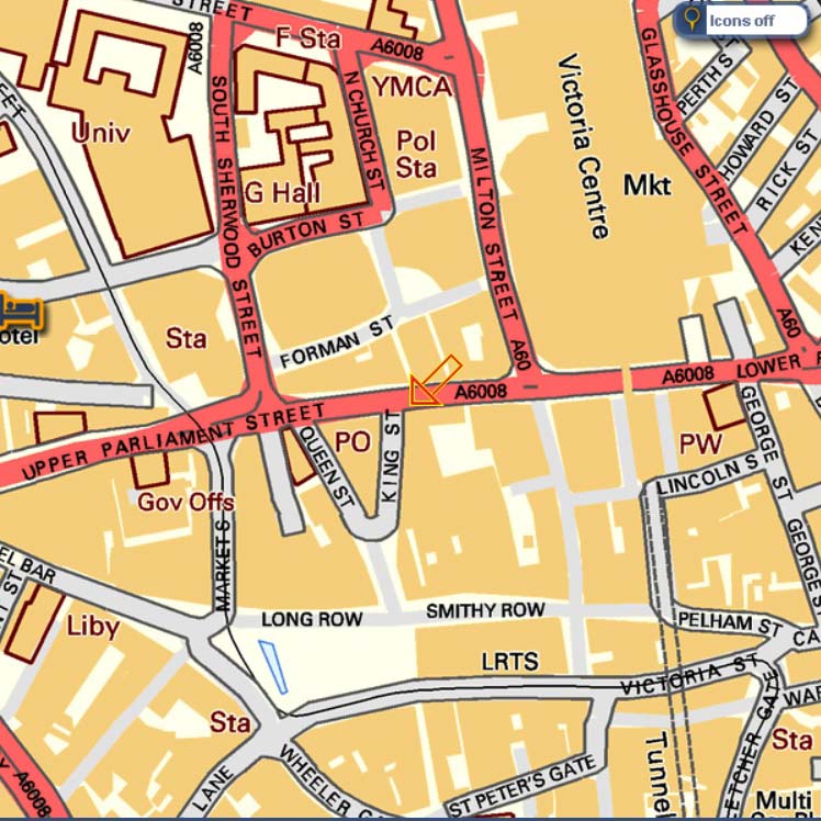
During this time, it was inevitable that, along with all the slums and all the undesirable features, a few other more reputable premises were destined to disappear. Among these was Richard Mellers’ Bell Foundry, which is known to have stood more or less exactly on the site of the present day Queen Street Post Office. The orange arrow points to the general area, and the letters PO stand for the purple edged Post Office:
Perhaps it was working so close to such an “immoral neighbourhood” that deflected Richard away from the straight and narrow. He had, for example, already paid out £20 to be the Mayor of Nottingham for twelve months. There wasn’t really much of the democratic process involved here, or indeed, much evidence of any genuine interest in the workings of democracy. That payment of £20, a rather sizeable sum of money by modern standards, may well have been the reason that, in the very same year, Richard had been so keen to do a good deed by paying for the upkeep of the ever ailing Hethbeth Bridge.
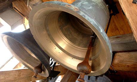
Richard was certainly widely known as a fairly unscrupulous businessman. During his lifetime, in his efforts to acquire great personal wealth, he certainly seems to have cheated many of his bell buying customers. In 1507, for example, we know that Richard had received a pardon for having committed offenses against the statutes of weights and measures. This charge is believed to have related to problems with the purity of his bells and the metal they contained. The pardon would only have been granted because of his previous position as Mayor of Nottingham. A less prestigious person would have been in very, very, serious trouble. These bells, though, are all 100% the real peal:
In a recent blogpost, I mused about the cold past of our city, and how the River Trent had frozen over on a number of occasions in the nineteenth century, the last being in 1892. Previous years when similar brass monkey weather conditions had occurred were 1682, 1814, 1838 and 1855. In all of these winters, the River Trent at Nottingham had literally frozen over from one bank to the other. I found these extremes of weather really quite interesting, so I continued to do further research of my own. I duly found some extra details, such as, for example, the sad fact that:
“on 10 January 1814, seven boys drowned in the River Trent in England by the breaking of the ice.”
One or two more examples of extreme cold have since come to light, in years of which I had previously been completely ignorant. During the winter of 1092-1093, for example, when William Rufus was king:
“the River Thames and all the English rivers (were) heavily locked in with ice”. There was severe frost in this winter. English rivers (were) frozen so hard that horsemen and wagons could travel on them.”
When warmer weather finally came, however:
“drifting ice on the rivers destroyed bridges, and mills were carried away”.
Here is William Rufus, who was to be killed by an arrow in the New Forest:
Four hundred years later, the River Trent was frozen near Nottingham in the winter of 1485-1486. When the thaw finally came, “the bridge at Newark-on-Trent was swept away.” In 1766, on February 15th, a great snowstorm hit Nottinghamshire, which lasted fifty hours. That is a lot of snow!
Our old friend “Wikipedia” provided a great deal of historical detail about this kind of event, not all of it totally fascinating, although the word “palaeochannel” was new to me and it does contain three unusual vowels in a row. Here’s one I photographed earlier:
I knew that Giant Floods generally follow any Big Freeze but it was interesting to see that, in the modern era, the worst flooding experienced in Nottingham came very soon after the vast snows of the winter of 1946-1947 had melted. This melt was extremely sudden because of continuous heavy rain throughout March. The result was extensive and severe flooding all along the valley of the Trent. During this flood the peak flow of the Trent was 39,100 cubic feet per second, thirteen times the norm. As many as 9,000 houses were flooded and almost one hundred industrial premises were awash, with floodwater up to the height of the first floor. Here are one or two photographs of the flooding. These are of West Bridgford:
This slideshow requires JavaScript.
Here is Arkwright Street next to the railway station:
This is the aptly named Canal Street:
Here is a picture of the River Trent near the present day Harry Ramsden’s and Toys-r-us. On the left is Wilford Power Station, demolished in the 1980s, and on the right, Clifton Colliery which disappeared even before this (possibly through flooding?):
Here is Beeston, looking remarkably like Venice:
This photograph is just about recognisable as Melton Road in West Bridgford:
This natural disaster in 1947 was the beginning of our modern attempts to tame the river, by building concrete embankments and sluices in an effort to avoid the surging floods which had devastated Long Eaton, Beeston, the Meadows area, Colwick and West Bridgford on more than one occasion during this period. Here is the Trent, with early concrete steps visible only on the far side of the river, and just a grassy slope on this, southern, side:
This photograph was probably taken in the 1950s, with concrete embankments on both sides. Trent Bridge is in the background, so we must be looking north:
Nowadays, the concrete steps near Wilford Suspension Bridge would stop a Soviet tank. Well, perhaps make them feel a little motion sick:
Here’s the other side, looking north towards Trent Bridge and the green roof of County Hall:
These are the sluices on the river between Holme Pierrepont and Colwick, designed to hold back excessive flood water so that it can be released gradually at sensible intervals. By the way, firm promises have now been given that the next time they release fifty billion gallons of floodwater, not only will they look first to see if any anglers are fishing at the riverside, but they will also sound a warning klaxon:
This huge construction work of the modern era seems to have been completely successful. During the Millenium Flood of November 2000, the peak flow of the Trent was 36,000 cubic feet per second, around twelve times the norm, and certainly comparable to the conditions experienced in 1946-1947. But this time, the 15,000 homes at risk were completely unaffected and there was none of the widespread flooding seen in 1947 within the city:
In this photo the flooded Trent is, for the most part, still contained within its banks, although Nottingham Forest’s pitch does look as if it may be somewhat waterlogged. All of the floodwater in the background, by the way, is, for the most part, lying harmlessly on playing fields.
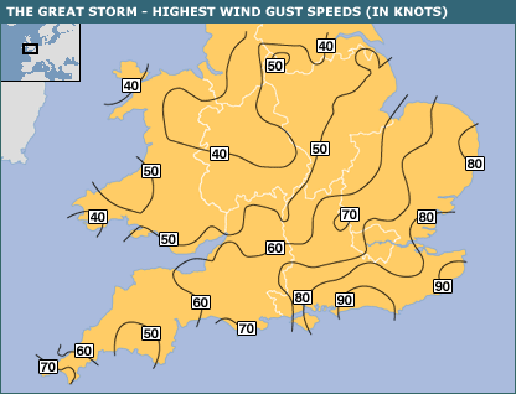
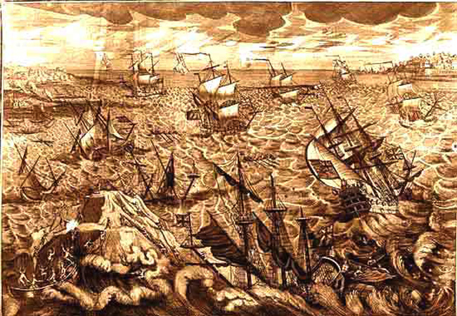
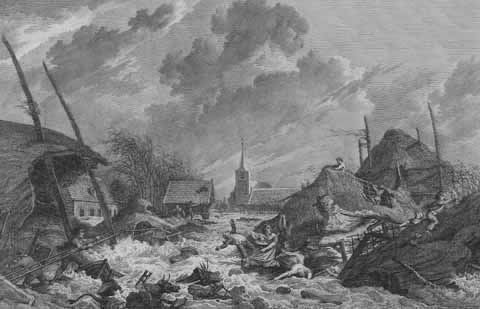
The Great Storm of November 1703 was reckoned to be the most severe storm ever recorded. The hurricane that struck the English Channel and the south of England was beyond anything in living memory:
Unlike today’s storms, when we have advanced warning and can prepare for the worst, the poor souls of 1703 had very little idea about what was about to hit them, other than the fact that the country had been buffeted by a persistent south westerly wind for quite a few weeks. Sailing ships could not sail against it and had therefore been confined in great numbers to whichever port they happened to find themselves near. Inland though, people were largely innocent of the catastrophe they were about to experience. Furthermore, the Great Storm persisted not just for a few shocking hours, but for nine terrible days. How could anything, buildings, ships, farm animals or men stand up against well over a week of wind speeds like those recorded in the eastern part of the English Channel or East Anglia? They would have approached 100 mph for long periods.
It has been variously estimated that between 8,000 and 15,000 people were to perish. John Evelyn, the seventeenth century diarist, described it in his diary as:
“not to be paralleled with anything happening in our age or in any history … every moment Job’s messengers brings the sad tidings of this universal judgement.”
The inhabitants of London felt the first strong breezes during the morning of Wednesday, November 24th 1703, (December 5th 1703 in our current calendar). By four o’clock in the afternoon the winds had noticeably increased. In London, recently out of prison, Daniel Defoe, the journalist, pamphleteer, spy, trader, writer and author, of course, of “Robinson Crusoe”, had a narrow escape in the street when part of a nearby house fell down and luckily missed him. On Friday the 26th, the wind began to blow with even greater ferocity and when the Great Man checked his barometer, he found the mercury had sunk lower than he had ever seen it. After midnight the gale increased to such strength that it was almost impossible to sleep. The noise of the chimneys of surrounding houses crashing into the street made the whole family afraid that their own solid brick townhouse might collapse on their heads. When they opened their back door to escape into the garden, they saw roof tiles scything through the air, some landing thirty or forty yards away, embedding themselves eight inches or more into the ground. The Defoe family decided to stay in their house and trust in the Lord.
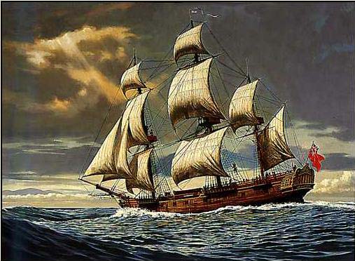
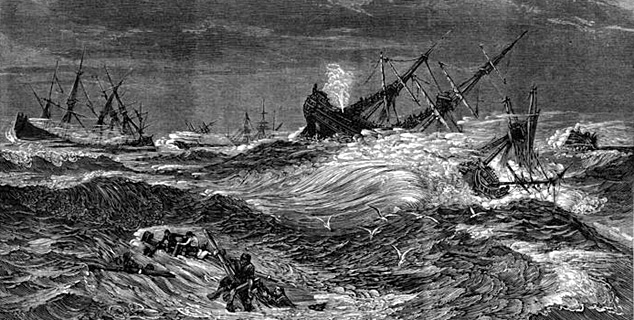
That night of November 26th-27th was catastrophic for the Royal Navy which lost 13 major warships, which were, for the most part, moored along the south coast. HMS Resolution was driven onto the shore at Pevensey but the ship’s company was lucky and all 221 sailors were saved:
Not so fortunate were the men on board HMS Restoration, HMS Mary, HMS Northumberland, HMS Stirling Castle and the quaintly named HMS Mortar-bomb, who were all shipwrecked on the Goodwin Sands off the Kent coast:
In the aftermath, when the tide fell, the sailors of the wrecked vessels who were able to find a foothold on the huge sandbar, were all wandering around knowing that when the tide rose they were certain to be drowned. It was said that a man called Thomas Powell, a shopkeeper in Deal, organised the rescue of some two hundred of them. Supposedly Powell was so appalled by his neighbours’ reluctance to help that he gave them five shillings each for their support. Certainly, the greedy citizens of Deal were widely accused of being more interested in plunder from the unfortunate ships than in helping to rescue the crew members. Indeed, some sources say that only three fortunate individuals survived the Goodwin Sands catastrophe. Supposedly, about 1,500 sailors in total were left to die.
Lots of other naval ships were driven through the Straits of Dover and out into the storm tossed expanses of the North Sea where some survived to return days later but many others were lost without trace:
Ships were so driven by the wind that not only did sails have to be lowered but the masts had be cut off level with the deck. Well in excess of a hundred merchant ships were sunk in the North Sea, many of which were colliers from the fleet which at the time was used to transport cargoes of coal down the east coast from Newcastle to London. Some of these ships would have been empty, moored or at anchor when the incredible tempest struck, casting them out into the open sea. Most were ill-prepared and foundered, and their crews perished to a man:
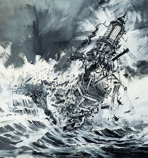
The storm caught a convoy of 130 merchant ships and the six Men O’ War escorting them as they sheltered at Milford Haven. The warships included HMS Dolphin, HMS Cumberland, HMS Coventry, HMS Looe, HMS Hastings and HMS Hector. By the middle of the following afternoon the losses amounted to thirty vessels. Overall it was estimated that more than 8,000 sailors perished as the storm annihilated the Royal Navy. Around 20% of its sailors were drowned. The first Eddystone Lighthouse was completely destroyed:
Its erection had been started a mere seven years before, and its light had been lit for the first time only on November 14th 1698. Now all six of its occupants were killed, including the brave builder Henry Winstanley.
This slideshow requires JavaScript.
This lighthouse was of inestimable importance and stood 120 feet tall, some twelve miles to the south of Plymouth, one of England’s most important naval harbours. Even the French valued it, when during the period of construction, a French ship took Winstanley and his men prisoner. King Louis XIV, “le Roi-Soleil” ordered their release, explaining that “France is at war with England, not with humanity”, « La France est en guerre contre l’Angleterre, non contre l’humanité! »:
The Great Storm reached its appalling apogee, its catastrophic climax, during the following night, that of November 28th-29th (December 9th-10th 1703). Between the south coast and the Midlands, entire villages from Northamptonshire in the north to Suffolk in East Anglia were devastated as the winds of the Great Storm rampaged across the country, striking hardest in the south and east of England, sending house roofs flying, flattening barns, razing everything in its path. Both men and animals were lifted off their feet and carried for long distances through the air. Roofs were ripped from more than a hundred churches, the lead was rolled up like a sheet of paper and dumped hundreds of yards away.
Millions of trees were blown over or uprooted; knocked flat in their tens of thousands, they lay prostrate in rows like soldiers mown down in battle. It was said that more than 4,000 oak trees crashed down in the New Forest. An attempt was made to count the flattened trees in Kent but the count was abandoned at 17,000. The diarist John Evelyn lost in excess of 2,000 trees on his own Surrey estate.
Every kind of building was totally demolished and salt spray was driven almost as far inland as Tunbridge Wells. Animals refused to eat the resultant salty grass.
The maximum wind speeds were similar to those of the Great Storm of 1987 but the bad weather lasted for much, much longer, well over a week, and thereby increased the enormous loss of life. Here is one of the enduring images of 1987:
People could not decide whether it was safer to stay in their house and risk its collapse or to go into the street where flying tiles killed large numbers.
In East Anglia the wind reached over 80m.p.h. and killed well over a hundred people. More than four hundred windmills were blown down. Many of them burst into flames because the friction of their sails spinning round at high speed caused their wooden machinery to catch fire. In Cambridge, part of St Mary’s Church fell down and the falling stones completely flattened the organ. It had only recently been installed at a cost of £1,500. Kings College Chapel was equally badly damaged with stone pinnacles toppled and many of the wonderful stained glass windows destroyed.
In the capital, around 2,000 massive chimneys were blown over. The roof was blown off Westminster Abbey and the Queen, Queen Anne, had to take shelter in a cellar at St James’s Palace to avoid falling chimneys and tiles whizzing off the roof. Daniel Defoe told how the Reverend James King of London wrote him a letter about a chimney which crashed down and buried a maid. She was thought to be literally dead and buried, but she came out the following day from a small cavity in the rubble.
Floods devastated the whole country, especially in the east of England and along the Severn Estuary. In the West Country in general, flooding was extensive and prolonged, particularly around Bristol where just under a thousand houses were totally destroyed. Hundreds of people were drowned on the Somerset Levels, where uncounted tens of thousands of farm animals, mainly sheep and cattle, perished. One lost ship was found fifteen miles inland. At Wells, Bishop Richard Kidder was crushed when two chimneys in the palace collapsed onto him and his wife, both peacefully asleep in their bed. Part of the Great West Window in Wells Cathedral was blown in and smashed to smithereens. At Fairford the church’s west window, facing the raging anger of the oncoming wind, bulged inward and crashed into the nave. In Wales, major damage occurred to the southwest tower of Llandaff Cathedral at Cardiff.
The storm began to die down around December 2nd, and on December 3rd, Daniel Defoe visited the Pool of London, where, in the section downstream from London Bridge, he saw more than 700 sailing ships all piled up into heaps one on top of another:
Daniel Defoe told the tale of the captain of a leaking ship who tried to escape what seemed to him at the time to be an inevitable death by drowning, and instead committed suicide—only for his ship to survive. One possibly taller tale related how a sailing ship at Whitstable in Kent was blown out of the foaming sea and then deposited more than a quarter of a mile inland.
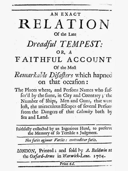
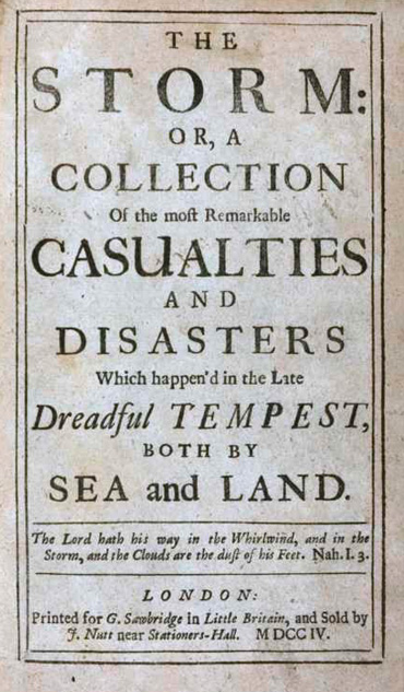
Unsurprisingly, in the aftermath of the Great Storm many special newspapers and publications appeared with information and eyewitness accounts:
Conceivably this disaster became “national news” in a way that had seldom, if ever, happened before. It was just like a modern “big story”.
Daniel Defoe himself sought out testimony from as many witnesses as he could find. When the weather ameliorated, he the whole country assessing the damage. He then produced what was subsequently described as “the first substantial work of modern journalism”, a book of more than 75,000 words, which was called “The Storm”. It was the first proper book of Defoe’s career.
Over the centuries, the weather can often be extreme, and some amazingly strange things have happened. In 1110, nearly a thousand years ago, Nottingham experienced a terrifying earthquake. Bizarrely, the River Trent dried up for several hours, presumably as it drained into, and then eventually filled up, a huge new crack in the ground that it had created somewhere upstream.
In the Nottingham of 1682, extremely low temperatures lasted from September until February of the next year. Shortages of coal, wood and food were caused by difficulties in the transport system, and the fields, roads and rivers were all frozen up. The Trent, for example, was completely impossible to navigate throughout the entire period of the freeze.
It was equally cold in 1855 when a cricket match was played on the frozen River Trent. The victors roasted, and ate, the greater part of a whole sheep without the ice either melting or giving way. When the thaw set in, an iceberg weighing many tons was unleashed in the river and it destroyed a bridge downstream when it crashed into it.
A local solicitor, William Parsons, recorded the weather’s outrages in his diary:
“In 1814, we had so severe a frost as to freeze the Trent over, the first time I believe. It continued 16 weeks. The Trent was then so frozen that a fair was held and oxen, sheep and pigs were roasted.”
In 1838, the River Trent froze over at the beginning of the year. William’s entry for January 20th reads:
“The frost has now continued about twelve days but with greater severity than is remembered. Many thousands from Nottingham went to see the Trent today. The frost continues extremely severe. The Trent this afternoon is now frozen completely over and I was sliding upon it just above Trent Bridge. I shall visit it tomorrow again it being of rare occurrence to be frozen. The snow continues upon the ground about six inches deep. My hands are very severely chapped that I am now writing in kid gloves”.
He described the river as:
“in that state frozen it appeared like a frothy, foaming river of snow. Many people were crossing on the ice. I walked down to the bridge and crossed the river just above it where numbers were also winding their way through projecting masses of snow covered in ice. The river was more rough and picturesque in this part than in any other.”
The most charming thing about William’s diary is his great honesty. As regards the consumption of alcohol in very large quantities, he was a man many years before his time:
“Time worse than wasted, money spent, health injured, myself debased! Let these days of drunken, senseless riot be remembered only as incitements to become a rigid teetotaller”.
We’ve all been there.
The River Trent was a very different river in those days and that is why it used to freeze fairly regularly during exceptionally cold weather. There were, of course, no power stations releasing huge quantities of warm water which might increase the natural temperature of the river, but that is not the most fundamental reason for the change. Nowadays, the waters of the Trent have been for the most part tamed and confined firmly in great ramparts of concrete. Because of the way in which the river has been turned into a giant canal, it is now much deeper and fast flowing than it used to be. The edges of the river do not extend outwards in leisurely fashion into marshes or shallow ponds with very little flow. The modern Trent no longer stretches, as it did in primeval times, from the sandstone cliffs south of St Mary’s Church for many, many hundreds of yards into present day West Bridgford. And the old wide river, of course, was a shallow, more slow flowing river, the kind of waterway that was much more likely to freeze in severe weather.
St Mary’s Church is in the top left of the map, near to the word “Museum”. It is represented by a cross and a square joined together. Trent Bridge is indicated by the orange arrow, and the southern edge of the waters centuries ago would have been well to the south of the present day B679 (bottom left of the map) or the Trent Valley Way (top middle right of the map).
In those ancient of days, when the river was so very much wider, the only safe crossing, either on foot or on horseback, was across the band of harder rock where Trent Bridge now stands.
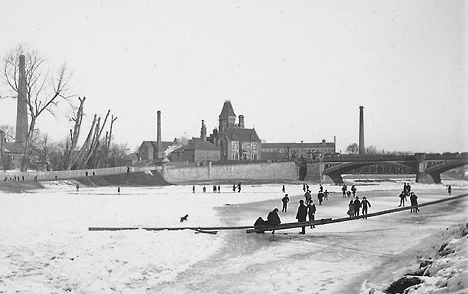
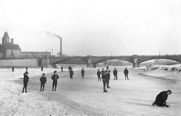
On January 16th 1892, on a “piercingly cold” Saturday, Nottingham Forest played Newcastle East End at the City Ground. When the crowd arrived at Trent Bridge, they were surprised to see “skating in progress on the old course of the River Trent.” Because of the recent introduction of the penalty kick, the frozen football pitch had some new markings, which in this case were made of broad strips of black soot. Newcastle changed from their normal crimson shirts into black and white stripes. Hopefully, before the game, Old Nottinghamian Tinsley Lindley, Forest’s centre forward, was able to walk across the Trent to the game, just like Brian Clough used to do.
Three years later, in 1895, the river froze for the last time. Again, the region’s economy suffered. Numerous tributary rivers smaller than the Trent were also frozen, and many jetties and warehouses became unusable. This caused huge job losses in local industry.
The river was caught in this devastating frost for almost a fortnight. Skaters were able to venture onto the safe and solid ice over many miles of the Trent’s length. The ice was thick enough to allow a hockey game between teams from Newark and Burton-on-Trent to take place on a pitch somewhere upstream from Averham Weirs.
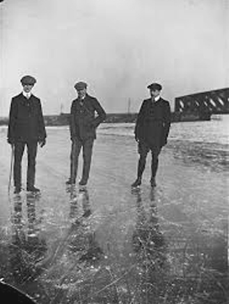
Here a huge crowd of boys are standing on the thick ice. Everybody looks very happy, but there were several fatalities, as people contrived to find excessively thin ice to stand on. Lady Bay Bridge can just be seen through the arches of Trent Bridge.
And not a scarf or a pair of gloves in sight. Kids were tough, and Health and Safety hadn’t even been thought of yet.
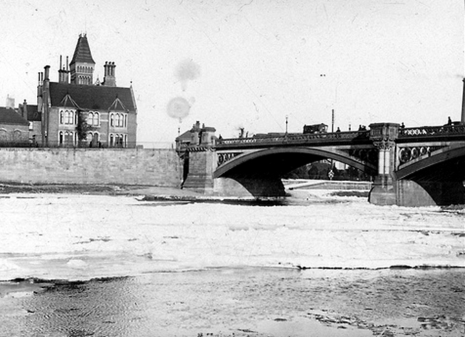
The photograph above was taken from opposite the West Bridgford embankment, to the south of Trent Bridge, near to the present day County Hall. Look for the orange arrow:
In places the extreme frost, the most severe in living memory, penetrated into the ground so deeply that it froze the tap water in the mains. Ordinary people suffered greatly and many had no water supply whatsoever, a parlous situation which was to last for several weeks. To overcome this most basic of problems, stand-pipes fitted with taps were set up at various places in the streets, and buckets could be filled up there. January and February of 1895 was a time of difficulty and danger for ordinary people and those who survived it were to remember it for the rest of their lives.
In the photograph above, a fire can be seen burning against the bridge, one of the many which blazed happily on the surface of the ice. The river’s rate of flow is reduced by the ice floes so much that it is almost reminiscent of a river during a drought.
During these bitterly cold winters at the turn of the twentieth century, my grandfather, Will, who had emigrated to Canada around 1905, saw Niagara Falls, for the large part frozen, on at least one occasion, this postcard dating most probably from 1911.
Strangely enough, the theme of murder runs bright scarlet through the early history of the High School. First, came George Somers, who was the Headmaster for an unknown period of time between, probably 1530, and , hopefully, not long after Friday, July 15th 1532.
Eighteen years earlier, in more probably April, but perhaps in early May, 1514, the Free School’s main benefactress, Dame Agnes had died.
She left much of her property to the school and was buried alongside her husband in St.Mary’s Church, Nottingham.
This slideshow requires JavaScript.
Within a few short years of Dame Agnes’ death, however, her high standards of morality were more or less forgotten. Money frequently went missing and both the Headmasters and the school wardens neglected their duties. A number of teachers appeared in court on various charges, which varied from failing to maintain the church windows to the theft of pupils’ books.
In perhaps January of 1532, the Headmaster, George Somers, was accused of stealing a featherbed, a long pillow, two short pillows, a green and red quilt, a covering and a pair of sheets to the value of 46s 8d. (£2.33p in modern money. Oh for a time machine!) Somers also owed twelve pence for the hire of the same bed. For what purpose has not been recorded. But you can probably guess…..
On Friday, July 15th of the same year, in a much more dramatic episode, George Somers, was now accused of murder. The Records tell how.
“…We indict the School Master of wilful murder.”
The incident had taken place almost a month earlier, on June 17th, and Somers had supposedly assaulted John Langton, Chaplain of Nottingham,
“by violence and weapons, namely a stick and daggers, of malice aforethought, and… had feloniously killed and wilfully murdered the same John, against the peace of our Lord the King.”
Unfortunately, the outcome of these events remains completely unknown, although it is devoutly to be wished that, if convicted, Somers did not keep his post as Headmaster of the school.
Hopefully too, this woodcut does not show Somers’ eventual fate. Notice the moment when the Mexican Wave was invented. Presumably it must be some Tudor oik losing his focus during the thirty seconds while the rope is put on.