Last time, I left you awaiting the arrival of Ragnar Lothbrok and his rather fierce friends in Anglo-Saxon Nottingham.
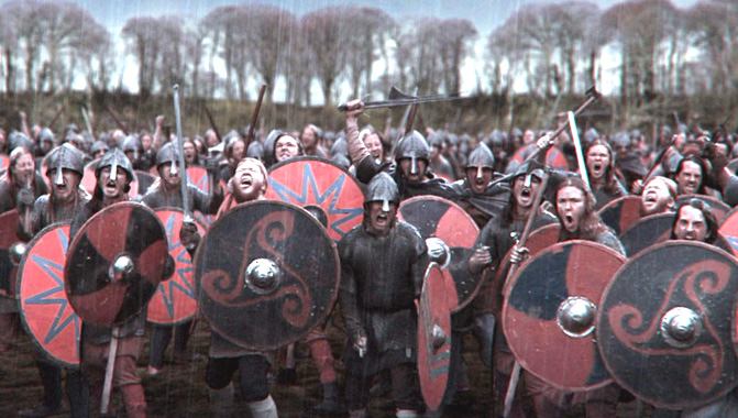
Well, by 867, Anglo-Saxon Nottingham had been well and truly captured by the Vikings and it became one of the Five Boroughs of the Danelaw. There may have been little in the way of extreme weather in this era, but their names were fabulous. The Five Boroughs of the Danelaw is a striking enough phrase, but the name of the army which made Snotingaham, at sword point, an offer they could not refuse, is, quite simply, wonderful. A thousand years before Heavy Metal bands, they rejoiced in the name of “The Great Heathen Army“. And here they are. They’re really quite handsome, aren’t they?
Then again, I really don’t see them as a group of people capable of waiting quietly for a bus: Another episode of extreme weather on the rain front came in 1141 when there was another Great Flood. And once again, the flooding was caused, as in 1947, by the mechanism of a sudden melt of large quantities of snow after prodigious amounts of rain. People in 1141 looked like this. Around this time there was clearly a significant risk for everybody of just rusting solid into one great mass:
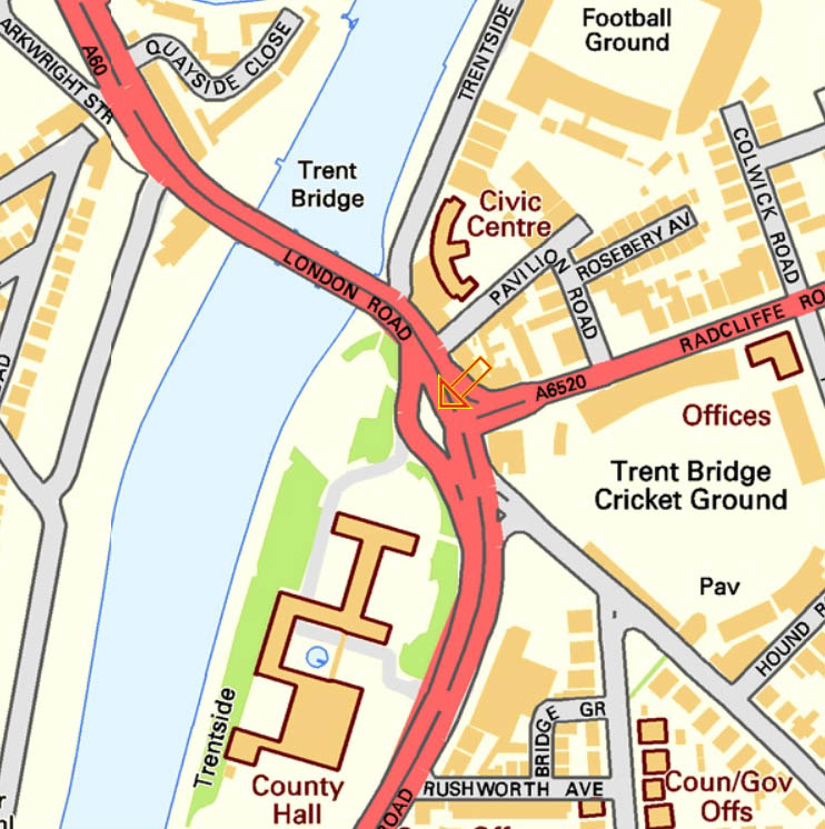
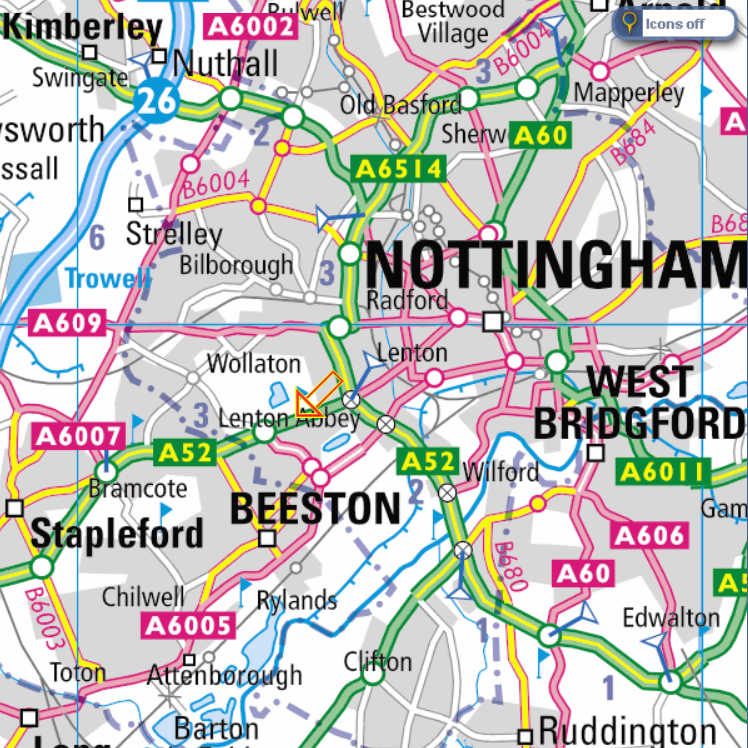
In 1309, Hethbeth Bridge, the medieval precursor of today’s Trent Bridge, was washed away by severe winter floods. A small fragment of this old bridge is still visible on the road island at the southern end of the modern Trent Bridge: If you go to see it, be very careful. Traffic nowadays is much more dangerous than “The Great Heathen Army”. Look for the orange arrow:
In 1346, little detail has come down to us, other than:
“from mid-summer to Christmas, the rains fell almost without intermission”.
The River Trent duly experienced:
“One of the earliest recorded floods.”
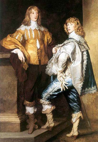
In 1499 Richard Mellers, the husband of Dame Agnes Mellers, of High School fame, is known to have given twenty shillings to help repair one of an apparent succession of Hethbeth Bridges, but it was pretty much in vain, as the Great Flood of 1683 washed a good proportion of it away. Here are two men in 1683. That’s not a look you can just throw together:
The worst ever flood in Nottingham was the so-called “Candlemas Flood” of February 1795, when two months of continuous ice and snow all melted extremely rapidly. Every single bridge on the entire River Trent was either damaged or washed away, including the Hethbeth Bridge for the umpteenth time. In the Narrow Marsh area of the city, around what is nowadays Canal Street and the land to the south of St Mary’s Church, the residents were all trapped in the upstairs of their houses and had to be given food from boats. At Wilford, up to 100 sheep were drowned and ten cows perished in West Bridgford. That doesn’t sound much, but they only had twelve.
The late eighteenth century provided some wonderfully ornate dresses, all guaranteed to keep you afloat until help arrived:
Another less severe flood came in November 1852 when the peak flow of the Trent was measured at some 38,200 cubic feet per second, between twelve and thirteen times the normal levels. A second, slightly worse Victorian inundation came in October 1875 when floodwater was up to six feet deep. During this latter flood the peak flow of the Trent was 45,000 cubic feet per second, fifteen times the normal levels. On Wilford Road an overcrowded cart was washed away and six people were killed. Higher up the river, huge numbers of farm animals were drowned and they must have been a ghastly sight as they floated down to the sea past Trent Bridge:
In a previous article, I wrote about the flooding of Nottingham during the modern era, and the ways in which we have learnt lessons from the floods of 1947 and constructed concrete embankments and sluices so that the River Trent is nowadays, to all intents and purposes, relatively tame. (“relatively” being the operative word.) If you walk down to Trent Bridge and look underneath the bridge on the City side, directly beneath the Riverbank Bar and Kitchen, however, you will see how the flood levels of previous years of watery disaster have been recorded. They are scarily impressive and well worth a visit:
This slideshow requires JavaScript.
The very first records of floods in Nottingham are more a case of inference than anything else. According to the (Royal) Journal of the Statistical Society, Volume XLI and “The Insurance Cyclopaedia” by Cornelius Walford (I need to get out more):
“29 A.D. There was a great overflow of the River Trent in England”.
In 214 A.D. the entire River Trent was again in flood and overflowed its banks by some 20 miles on each side from the normal course of its flow. Many people were drowned as the whole Trent valley was awash and there was great destruction. Both of these dates are during the Roman era, although Nottingham was not, as far as I know, a Roman town. Perhaps they knew that an underlying band of hard rock could be used to ford the river and its adjacent marshes. Just to establish our dates firmly, here is a Roman. Like every single Roman, he is a legionnaire, although he doesn’t look particularly ill to me, but that hat is really something: In 525 A.D. the entire Trent again burst its banks and a great number of cattle were drowned. The locals at his time may well have been Celts since we know that Nottingham, in the Brythonic Celtic language was called “Tigguo Cobauc”, meaning “The Place of Caves”. The Welsh may have been aware of Nottingham’s existence since they called it “Y Ty Ogofog” and even the distant Irish had a word or two for it, namely “Na Tithe Uaimh”, “The Cavey Dwelling”. Here are some Celts, managing to appear very, very fierce indeed, although admittedly, there is more than a dash of Village People in the overall look, especially the one at the front who may have no clothes on at all: Whoever the locals were in 530 A.D., they would certainly have got extremely wet at some point. The mighty River Humber is known to have flooded extensively onto adjacent low-lying ground and most of the region’s cattle were drowned. Much of that excess of water, of course, was bound to have come from the River Trent, which feeds into the Humber. It is difficult to see how Nottingham, at the side of the River Trent, of course, could have escaped floods of such severity. It was slightly after this date that Nottingham, by now a small group of wooden huts and a line of washing, came under the sway of the wonderfully named “Snot”, an Anglo-Saxon chieftain. The place where “The Mighty Snot” lived was immediately called “Snotingaham”, the “home of the people of Snot the Magnificent”. At this time, “Snotingaham”, was part of the Kingdom of Elmet. Here is an Anglo-Saxon chief and his friend. What impressive elmets they are wearing:
I just couldn’t resist that!
Next time, we will see what happens when Ragnar Lothbrok and his pals arrive in Nottingham on a seven-day-cruise in 867AD.
Derby Road seems reasonably peaceful now, but not in 1701, when Timothy Buckley, a 29-year old criminal from Stamford, Lincolnshire, was arrested after a ferocious gun battle as he tried to rob a stagecoach on its way to Derby. The coach contained three gentlemen attended by two footmen. Buckley had previously been a shoemaker’s apprentice in London, but gradually became a more and more hardened criminal after his return to Nottinghamshire and the Wild North.
Beyond “two miles from Nottingham”, we do not know exactly where this gun battle took place, but usually, highwaymen would strike as the coach was moving uphill, and was therefore travelling at its very slowest pace.
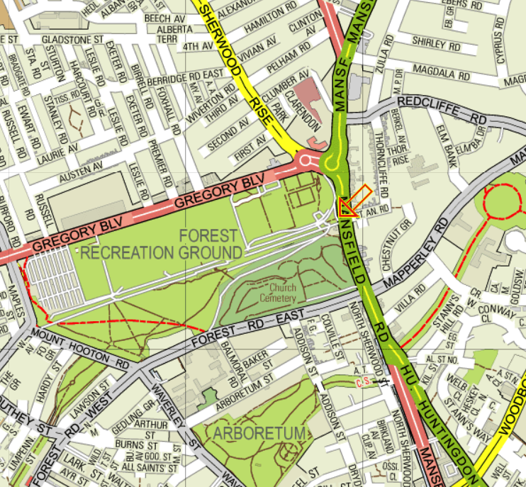
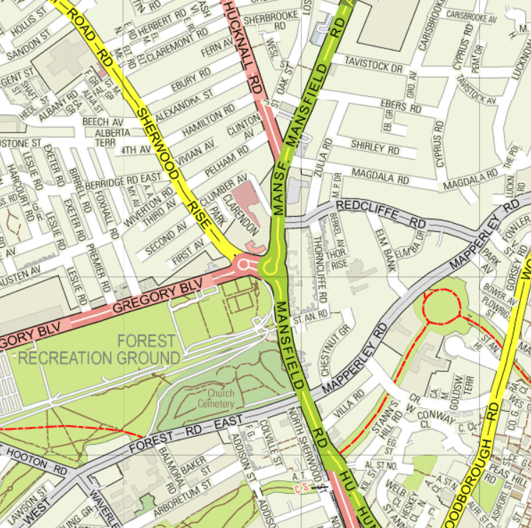
To me, the steep slope near the present day St.Barnabas Cathedral is too close to the city centre, so my best guess would be that stretch of the A52 as it climbs steadily after the present-day Ring Road, between the back of Wollaton Park and the grounds of Nottingham University. On this map, look for the orange arrow which is over the green A52 road with the words “Lenton Abbey” written over it. If the incident was any further on, then it might have been on the shorter slope near to the present day Bramcote Leisure Centre.
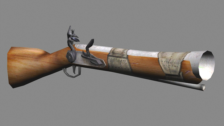
No sooner had Buckley commanded the stagecoach to “Stand and Deliver, Your Money or your Life!”, than one of the passengers, unwilling “to submit to a single bravo”, blasted him with a blunderbuss. Buckley’s horse was shot out from under him, and died instantly.
A blunderbuss was a murderous weapon, used for close-in fighting, in the words of Wikipedia, “when it was unimportant to protect objects around the intended target”. This formidable firearm was loaded with shot and anything else the user thought might do the job, small pieces of metal, nails, bits of rock or stone, or even salt. It was flared at the muzzle, and was the 17th-19th century equivalent of the shotgun so beloved of Wells Fargo personnel.
Interestingly, the military term dragoon is taken from the fact that early blunderbusses (or should that be “blunderbi”?) were decorated with dragon’s heads around the muzzle, and the blast would seem a little like the fire of a real dragon.
Buckley was not lightly armed either. He was carrying eight horse pistols. The largest were up to twenty inches long, and were carried in holsters across the horse’s back just in front of the saddle. This seems an unlikely number of such large weapons, but perhaps some were coat pistols (carried in the pocket of a greatcoat) coach pistols, (carried in a saddlebag perhaps), or belt pistols, (carried on a belt, hanging from a hook).
In any case, Buckley was very attached to his favorite horse and enraged by its untimely demise, “a most desperate conflict ensued”. Buckley let fly with all his pistols.
One male passenger and a footman both fell dead, shot through the heart. Eventually, though, Buckley was overcome by the remaining occupants of the stagecoach, as he grew gradually weaker and weaker from loss of blood, caused by his eleven severe gunshot wounds.
After a brief trial at Nottingham Shire Hall, Buckley was found guilty and was later hanged. He was only 29 years of age, and he was sentenced also to be “hanged in chains”. I don’t know how long his rotting cadaver was left exposed to the elements, but as a birdwatcher, I certainly know that there was one famous case in Nottingham where a dead criminal decayed over the course of the winter, helped by passing crows and magpies, only to have, with the advent of spring, a pair of blue tits raise their young inside his empty skull, using his eye sockets to go in and out, perhaps even operating their own one-way system.
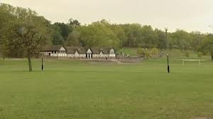
As these events all took place in 1701, Buckley would have been executed on what is now “The Forest Recreation Ground”. Centuries ago, “The Forest”, was called “The Lings” and was a very different place from what it is like nowadays. Largely covered by gorse and scrub, it was considered to be the southernmost part of Sherwood Forest itself. It was only as late as 1845 that, under the Nottingham Inclosure Act, some eighty acres of Sherwood Forest were set aside for recreational use. This area became “The Forest Recreation Ground” and to commemorate the event the Mayor of Nottingham planted a special Oak tree called the “Inclosure Oak” which can still be seen today at the Mansfield Road entrance. The orange arrow marks the oak tree:
Pretty well straightway, the area became a site for sports and shows, or a combination of the two.
In the summer of 1801, four butchers held their weddings there simultaneously, and decided who was to pay for the wedding picnic by holding a donkey race, with four animals, each equipped with mascots taken from the wardrobes of their respective owners’ new wives. The race was easily won by the donkey which had corsets attached to his tail with a bow of green ribbon. In second and third place were the animal with a pair of stockings around its neck, and another with a saddle made out of a nightgown. Needless to say, the donkey wearing a voluminous pair of ladies’ drawers was placed last.
By this time, the Forest had already been a horse racing course for well over a hundred years. Not long before that, bear baiting had taken place on the very site where the horse racing course was later to be constructed. In 1798, a new horse racing track in the form of a figure-of-eight was built. Unfortunately, this rather novel choice of layout, designed to give the maximum length of course in the smallest possible area, was not overly successful, as spectators did not have a sufficiently good view. Crashes between horses were apparently too infrequent to compensate for this.
By the middle of the nineteenth century, though, there were at least two major race meetings per year, in spring and autumn, and the area was beginning to attract the same kind of people who can still be found there nowadays, well over a hundred and fifty years later…
“…loiterers…policemen…tooting footmen…toddling children…enterprising
vendors… overcharging greenhorns…patterers, chanters and beggars…sailors without arms or legs… “downy blokes”…holiday makers….villains…detectives …boozers and nymphs of easy virtue…ministers of religion……“black sheep”…enterprising merchants…aristocratic swells… pleasure seekers…a few robberies, a few drunks, a few fights…married men, sitting in the drinking places at the Stand with an assemblage of whores…the unemployed poor…”
Indeed, with whisky at an all-time low of 75p a gallon, so unsavoury did the area become that in 1879, male members of Nottingham University staff were threatened with instant dismissal if they were ever found at the horse races.
Other sports were played there as well. From 1865-1879, Nottingham Forest both practiced and played soccer here, being known therefore as “Forest Football Club”. Cricket was widely played in the summer, as were types of field hockey known variously as bandy, shinney or shinty.
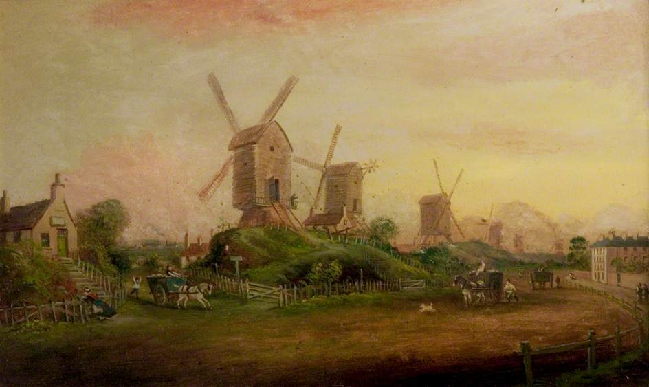
Apart from sport, alongside what is now Forest Road East, there was a long line of thirteen windmills, all taking advantage of the strong winds and updrafts which blew across the open ground lower down to the north.
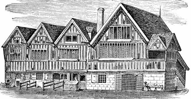
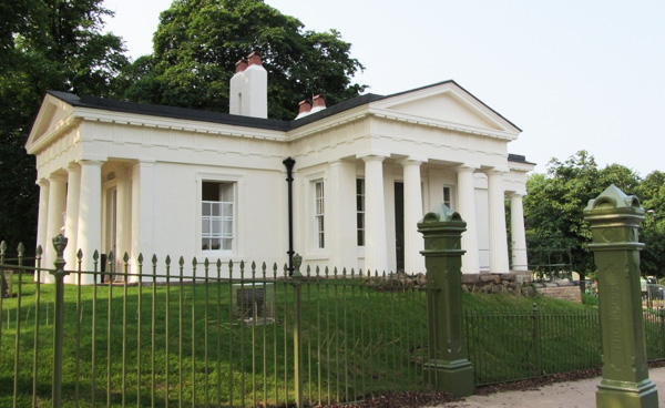
The exact place where the gallows stood and where Tinothy Buckley met his Maker has not necessarily been recorded absolutely accurately. Public executions took place here until as recently as 1827, and I am fairly certain that, many years ago, I read that the gallows used to stand a little distance down Mansfield Road from St.Andrew’s Church, within the present day Rock Cemetery. This was to the south of the white, recently refurbished, Lodge House. Clearly, in the latter part of the nineteenth century, there was still some judicial rôle for this building to fulfil, as it was originally used as a Police or Keeper’s Lodge and a police cell can still be seen at basement level.
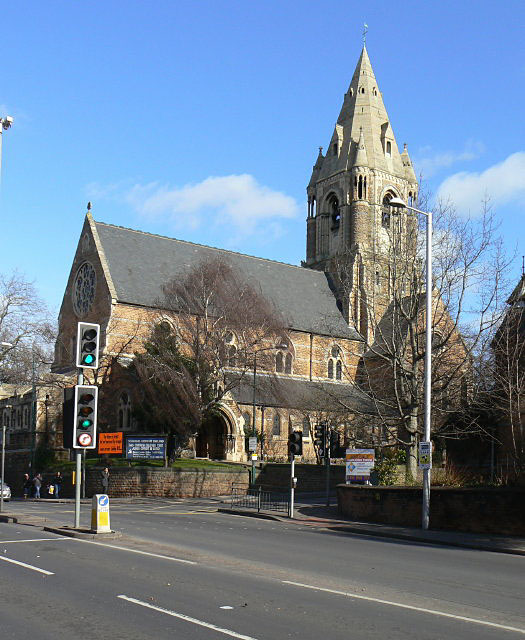
Others say that there was a gallows on the same site as present-day St.Andrew’s Church, and, indeed, when excavation work was done here in 1826 for the church foundations, more than fifteen apparently medieval skeletons were found. This was presumably connected with a much earlier era, when travellers left the City of Nottingham through the gate in the mediaeval wall near what is now the Victoria Centre branch of Boots the Chemist. As they climbed painfully slowly up the hill which is now Mansfield Road, stagecoach robbers and mere footpads would sometimes pounce at Forest Road: hence the gallows which were constructed here, and might even have concentrated the thieves’ minds a little as they waited to swoop upon their prey from behind the bushes.
“Garner’s Old Nottingham Notes” (date unknown) somehow contrive to be both illuminating and yet somehow confusing…
From information given, the gallows appear to have been erected on the level ground which now forms the upper portion of the Rock Cemetery, and it was probably 100 yards or rather more from Mansfield Road…..
Judging by the large old official map of the borough, measuring from the present Forest Road East, I consider it probable that, going northwards, the site of the gallows was about 100 yards from the southern boundary of the Rock Cemetery, and probably rather more from Mansfield Road, according to the contour of the ground, as depicted upon the official map. There is much likelihood that the gallows was erected near to where the last windmill on that side of the Forest then stood or was afterwards constructed.
It is certainly proper to state that I have seen two or more old maps on which the ground now covered by St Andrews Church, and southwards from there, is entitled Gallows Hill. The upper part of the ground is no doubt higher than any portion of the Rock Cemetery, and I have thought that this might possibly be the original place on which the gallows stored a few centuries back and perhaps afterwards were moved to the spot above designated.”
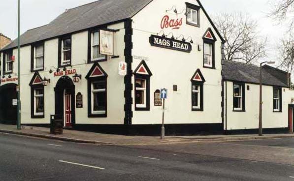
Wherever the exact location of the gallows, when convicted prisoners were to be hanged, they were usually brought from the County Hall in High Pavement, or the Town Hall at Week-day Cross, through the maze of streets in Hockley, and then walked along Clumber Street, Milton Street and finally up the hill along Mansfield Road. Prisoners were entitled to one last drink at the Nag’s Head Public House, which was traditionally paid for by the landlord.
There is, of course, a traditional tale, told no doubt, of every road with a set of gallows and a public house. One particular prisoner, who was a teetotaller, therefore, refused his last mug of ale at the Nag’s Head. He was taken straight on to the gallows and duly hanged. Seconds later a much flustered horse rider came galloping up the hill, and screamed to a halt by the little knot of people. He was waving a piece of paper which was, of course, the Royal Pardon for the Recently Hanged Man. Had the latter been just a little later in arriving at his place of execution, then he would have been saved. The “little later” of course, is exactly the time it takes to quaff a pint of ale.
The last person to be executed at these gallows on Forest Road was William Wells, a 45 year old native of Peterborough, who had robbed James Corden in Basford Lane and Mansfield Road on March 7th 1827. He was executed on April 2nd 1827.
Not all highwaymen meet with disaster however. Just occasionally one of them can make that leap from criminality to superstardom…
This amazingly spikey plant is called a “teasel”, and it is easily the most fascinating plant in our garden.
It is a very thrilling plant from an English point of view, for, alas, we just do not seem to have the same exciting inhabitants in our gardens as they have in the USA…..
These American killers are deadlier than wolves or bears.
Our English plant, though, can consume a reasonable number of insects, medium sized mammals and small children.
It performs this valuable service by drowning them, and then absorbing their nutrients. Equally well, you can easily feed the plant yourself by tipping in the dregs from your cup of tea or coffee. On this caffeine based diet, our plant has now reached an amazing twenty seven flower heads. Here are two of them….
The biggest flower heads are now in bloom. They provide a fabulous source of nectar for all kinds of interesting flying insect, especially butterflies….
This is a Peacock…
This is a Red Admiral. Its Latin scientific name is “Vanessa atalanta”, which sounds a little bit like one of the old Admiral’s girls in every port…
The flowerheads are a lovely bluey-pink colour…
Eventually seeds will appear. Indeed, in our worryingly early autumn, many have already arrived as early as the fifth of August.
This slideshow requires JavaScript.
The seedheads are an absolute magnet to England’s most colourful bird, the improbably beautiful Goldfinch…
The population of these splendid birds is gradually increasing, and teasels are an excellent way to entice them into your garden.
This could easily be your garden…
I would be very surprised, though, if you managed to attract as many of these beautiful birds as Gunnar Fernqvist has done, although, to be fair, he does seem to have a VERY large garden.
Interestingly, the Goldfinch has always been of great symbolism in medieval European art. According to Wikipedia, because of the thistle seeds it eats, and the spiky nature of the adult thistle plant, the goldfinch is associated with Christ’s crown of thorns. When it appears in pictures of the Madonna and child, the bird is thought to represent the knowledge both Mary and Jesus had of the latter’s Crucifixion.
This slideshow requires JavaScript.
Teasel seeds can be found fairly easily on your local brownfield site in late summer or early autumn. Otherwise, it’s another expedition up the Amazon.co.uk….

 Another episode of extreme weather on the rain front came in 1141 when there was another Great Flood. And once again, the flooding was caused, as in 1947, by the mechanism of a sudden melt of large quantities of snow after prodigious amounts of rain. People in 1141 looked like this. Around this time there was clearly a significant risk for everybody of just rusting solid into one great mass:
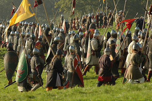 In 1309, Hethbeth Bridge, the medieval precursor of today’s Trent Bridge, was washed away by severe winter floods. A small fragment of this old bridge is still visible on the road island at the southern end of the modern Trent Bridge:
 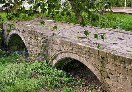 If you go to see it, be very careful. Traffic nowadays is much more dangerous than “The Great Heathen Army”. Look for the orange arrow: