Tag Archives: River Trent

What would you do ? (19) The Puzzle

“What would you do ?” used to figure on the cover of a boys’ comic called “Boys’ World”. This was a publication, obviously, aimed at boys and first appeared on January 26th 1963. There were 89 issues before the comic was merged with Eagle in 1964. The last issue of “Boys’ World” came out on October 3rd 1964.

I used to buy “Boys’ World”, and this was mainly for the front cover which always featured a kind of puzzle. It was called “What would you do ?” and was based on somebody being in what Ned Flanders would call “A dilly of a pickle”. Here’s the situation:

The yellow box sets the scene, and the task is for you to solve the situation. Perhaps you might like to write your idea in the “Comments” section.

Here’s the yellow box enlarged:

So…..it’s one “Dilly of a pickle”.  A thousand hooves thunder across the American plains as the bison all set off in a frightening stampede. In their path stands Buffalo Bill, an All-American Hero, but  armed at this moment with only a single shot rifle. His revolver will be useless and against these terrified huge animals, his one bullet will not kill the herd.

What can  he do??

Incidentally, Buffalo Bill and his famous Wild West Show came to Nottingham, accompanied by riders of many different nationalities, such as Lakota and Cheyenne Native Americans, Argentinian gauchos, Russian Cossacks, Mongols and Turks, all of them expert riders. They camped on grassland between the southern bank of the Trent and the houses of that part of West Bridgford, but I have been unable to discover where they performed.

After one Saturday matinée, a stand holding 800 people collapsed, but the only damage was one broken ankle, a very lucky escape for everybody.

30 Comments

Filed under History, Wildlife and Nature

Newark Air Museum (1)

The original Newark, or Newark-on-Trent, is a market town in Nottinghamshire in England. It stands on three important routes, namely the River Trent, the ancient Great North Road or A1, which ran from London to Edinburgh and it is also on the main East Coast railway line:

Newark has an historic castle which was “slighted” or put beyond military use in 1648.

Outside the town, Newark also has an air museum.

Nowadays going out to visit anywhere is not really feasible for me, so my daughter went as my ambassador, accompanied by her boyfriend, urged to take photographs of whatever she thought was a warplane. And she is no aviation expert, but she certainly knows a hawk from a handsaw and a Halifax from a Hastings. She wouldn’t know a Hampden from a Hereford, though, or a Harrow from a Sparrow or a Bombay. Who would?

The majority of Newark’s aircraft are from the 1950s and the Cold War. Here’s an English Electric Canberra PR7, the photo-reconnaissance version. This one, WH 791, served at RAF Tengah in the western part of Singapore. Top speed : 580 mph

This is a Gloster Meteor two seat conversion trainer, the T7. This particular aircraft, VZ634, was in service from 1949-1958 with 247 Squadron, 609 Squadron, 141 Squadron and 41 Squadron. As a fighter, the Meteor was used by 16 foreign countries and Biafra. Top speed : 585 mph

Here’s another fighter, the Hawker Hunter. At Newark, it’s an F.1 interceptor fighter, waiting eagerly for those Bears, Bulls and Badgers to show their evil Commie faces over the North Sea. Hunters were used by 21 other countries and had a Top Speed of : 623 mph. Nowadays everybody seems to have forgotten “The Black Arrows” aerobatic team and their manœuvre with 22 aircraft, certainly a world record at the time. There’s a link here.

The de Havilland Sea Venom was a two seater shipboard strike fighter, one of the comparatively few aircraft to have been twin boom. At Newark there’s an “FAW.22” or “Fighter All Weather”, WW217, one of only 39 built. There’s a family tree here, starting with the de Havilland Vampire, then the Venom, the Sea Venom and finally the Sea Vixen which operated from carriers as late as 1972.

This is the Avro Shackleton, the last in the line which ran from the Avro Manchester to the Avro Lancaster to the Avro Lincoln and finally to the Avro Shackleton. It was a long-range maritime patrol aircraft, and was used by the British and the South Africans. Top speed : 302 mph

Here’s a closer view of some of those propeller blades:

The only American warplane here is the North American F-100D Super Sabre, a single-seat fighter-bomber. This individual was used by France’s Armée de l’Air, and served in France, Germany and the old French colony, Djibouti in the Horn of Africa, today’s Somalia. In total, it had a career of 4,459 hours in the air. Top speed : 924 mph, Mach 1·4.

I think it was an F-100 that dropped the napalm in “Apocalypse Now”:

Next time, a look at some of Newark Air Museum’s civilian aircraft, some more of its foreign aircraft and its various bits of aircraft.

20 Comments

Filed under Africa, Aviation, Bomber Command, Film & TV, France, History, military, Personal

Fred walks home on leave

One beautiful summer’s afternoon, Fred was returning on leave from his airbase at Elsham Wolds in north Lincolnshire. The orange arrow is RAF Elsham Wolds, and Fred departed from a station near Elsham before continuing to Lincoln, to Nottingham and finally to Derby:

Derby was, and is, a huge station by English standards:

Fred arrived on time at Derby station, but there were no more trains to take him on to Burton-on-Trent (bottom left on the map above). He decided therefore to walk the twelve miles back home to the little mining village of Woodville, something which he had often done in the opposite direction in pre-war years, when he had been to watch Derby County play football at the Baseball Ground.

It was a Sunday, and after a couple of miles or so, Fred crossed the River Trent over the five spans of Swarkestone Bridge:

Fred then continued across the meandering  stone causeway, built by the Saxons, which crosses the floodplain of the River Trent. Things are a little bit different nowadays:

Or at least, things are a little different from what Fred would have known. These two photographs are taken from the same spot, but are separated by at least a century :

After the meandering charms of the ancient crossing, Fred then set off to the right, up the hill, towards the next village of Ticknall. As the evening moved slowly ever closer to sunset, everything grew very calm and very still, the light hovered on the edge of dusk, and just as he reached the top of the first long steady rise, Fred could hear, ringing out through the silence, the bugle sounding the Last Post at the nearby German prisoner of war camp:

Fred stopped to listen as the familiar notes echoed in evocative fashion over the late evening landscape, as the bright light of the sinking sun illuminated a pastoral scene in an England which is now long gone and will never return. It was a uniquely beautiful and unrepeatable moment in his life:

During the rest of his lifetime, Fred was never aware of a couple of facts about this moment. Firstly, he always thought that the prison camp was at Castle Donington but in actual fact it was somewhat closer to where he was, at Weston-on-Trent. I know that because I have just looked at the list of all the POW camps in the country.

Secondly, as he walked through the village of Ticknall, under the bridge which used to carry the railway to the limestone quarry…

…as he walked past St George’s Church…

….he did not know that the building held, hidden away somewhere in a safe place, a great many records of his own family history. He did not know that his family had been baptised there, married there and buried there for centuries. They included…

his own grandfather, John Knifton (1850-1934), John’s father, Thomas Moor Knifton, and his mother, Jemima Knifton, and her mother, Katharine Knifton, and then her father, Richard Kniveton and lastly, George Kniveton, born, in all probability, before 1700.

Another England which is now long gone and will never return:

Fred would have walked past all the old water pumps at the side of the road, every fifty yards through the whole village. I bet some of them were still working then. If Fred had done his long walk previously, he might even have known which pumps could slake his thirst after perhaps seven or eight miles of walking:

Fred could not possibly have known, though, that only fifteen years later, in his Connaught green Austin A40 Devon saloon, he would drive, not walk, through the village, and his young son would count the pumps out loud as they passed along. Fred didn’t know that that was going to happen in the near future. He was too busy in the present, fighting to make sure that England had a future:


16 Comments

Filed under Aviation, Bomber Command, History, Personal

A Twitch to Kent : Day One

Friday, October 14th, 1988
This is a new venture for me. A minibus trip, to Kent for a whole weekend. Surely we’ll get to see something. I am looking forward to a chance to see the famous Glossy Ibis:

Glossy_Ibis_1700_e

I may possibly get a glimpse of Ring-necked Parakeet, if we’re lucky:

flock parakeete

They’re a lot better close up:

parak

There’s also a fair number of other birds scattered around the country and I start an exciting war of nerves in the minibus, trying to persuade everybody that it would be an extremely good idea to call in and see them all.

I have taken the unpardonable sin of producing a dozen photocopies of an article about the habits of the Stodmarsh Glossy Ibis. A lot of people who had up to now never heard of the bird, are soon warming to the idea of going to see it. A mention of the Isabelline Shrike however, is not quite as successful, since almost all my fellow passengers have a very accurate idea of just how far away Dorset is.

On the Saturday afternoon we move over to Stodmarsh, where by now, we all expect to see the Glossy Ibis, flying over our heads on its way to roost, as it is supposed to do every single night. It can be seen flying in over the Lampen Wall. But just what is a Lampen, and why do we need to be protected from it?

view from lampen wall

In the late afternoon, the reserve doesn’t really have a lot on show. I wait in vain for a Cetti’s Warbler, a bird, that to my eternal shame, I have yet to see, although I have heard a lot singing in Norfolk.
The Stodmarsh logbook by the car park says that the Ibis came in to roost at 4 o’clock the previous evening. That’s a bit of a frightening thought, because we don’t manage to get there until 4.15 and I have the horrible nagging feeling that we have all missed it .
The minutes tick by as we wait for the bird. We get more and more worried. At least, the
serious birdwatchers do. Some of our fellow travellers act as if there is a Glossy Ibis resident in every county in the British Isles, instead of just one single, lost, bird in the whole country.

4.45. Nothing

5.00. Nothing
We get so desperate that Paul puts into operation the ultimate birdwatching spell. He inserts his index finger into the handle of his tripod, followed by the whispered recital of the bird’s Latin name. The spell works a lot better if you haven’t looked up the Latin beforehand, but actually know it anyway.
And of course it works. Within a few short minutes, Wayne is shouting, “I think I’ve got it.”

And just for once, he is actually right.

gloucsglossyibis

The bird flies over, circles a few times, and finally drops down into the reeds, presumably into its roosting place.

It is supposed in all the books to be particularly primitive looking, but I think it’s absolutely superb. It has rounded wings which seemed almost transparent against the light of the sky, and its improbably long bill balances perfectly the dangling legs. And it is is nowhere near as awkward in flight as the descriptions would have you believe. It circles around us, light and graceful. It even earns a spontaneous round of applause from its admirers. It is certainly the best bird I’ve seen so far in my very short birdwatching career. Easily.

glos ibis

Nowadays, with the alleged advent of Global Warming, the Glossy Ibis, usually a bird of Southern Europe, is being seen with increased frequency in England. A little while back, one even came to spend a few weeks in a wet field down by the River Trent in Nottinghamshire:

glossyibis2 nottnm


22 Comments

Filed under History, Science, Twitching, Wildlife and Nature

More and more water, most of it under Trent Bridge (2)

Last time, I left you awaiting the arrival of Ragnar Lothbrok and his rather fierce friends in Anglo-Saxon Nottingham.

Well, by 867, Anglo-Saxon Nottingham had been well and truly captured by the Vikings and it became one of the Five Boroughs of the Danelaw. There may have been little in the way of extreme weather in this era, but their names were fabulous. The Five Boroughs of the Danelaw is a striking enough phrase, but the name of the army which made Snotingaham, at sword point, an offer they could not refuse, is, quite simply, wonderful. A thousand years before Heavy Metal bands, they rejoiced in the name of “The Great Heathen Army“. And here they are. They’re really quite handsome, aren’t they?

Then again, I really don’t see them as a group of people capable of waiting quietly for a bus: vikingsaaaa Another episode of extreme weather on the rain front came in 1141 when there was another Great Flood. And once again, the flooding was caused, as in 1947, by the mechanism of a sudden melt of large quantities of snow after prodigious amounts of rain. People in 1141 looked like this. Around this time there was clearly a significant risk for everybody of just rusting solid into one great mass:

NormanAdvanceIn 1309, Hethbeth Bridge, the medieval precursor of today’s Trent Bridge, was washed away by severe winter floods.  A small fragment of this old bridge is still visible on the road island at the southern end of the modern Trent Bridge: 771942beth heth xxxxxxxxxxx If you go to see it, be very careful. Traffic nowadays is much more dangerous than “The Great Heathen Army”. Look for the orange arrow:

trent

In 1346, little detail has come down to us, other than:

“from mid-summer to Christmas, the rains fell almost without intermission”.

The River Trent duly experienced:

“One of the earliest recorded floods.”

In 1499 Richard Mellers, the husband of Dame Agnes Mellers, of High School fame, is known to have given twenty shillings to help repair one of an apparent succession of Hethbeth Bridges, but it was pretty much in vain, as the Great Flood of 1683 washed a good proportion of it away. Here are two men in 1683. That’s not a look you can just throw together:

Cavaliersxxxxxxxxxxxxxxxxxxxxxx

The worst ever flood in Nottingham was the so-called “Candlemas Flood” of February 1795, when two months of continuous ice and snow all melted extremely rapidly. Every single bridge on the entire River Trent was either damaged or washed away, including the Hethbeth Bridge for the umpteenth time. In the Narrow Marsh area of the city, around what is nowadays Canal Street and the land to the south of St Mary’s Church, the residents were all trapped in the upstairs of their houses and had to be given food from boats. At Wilford, up to 100 sheep were drowned and ten cows perished in West Bridgford. That doesn’t sound much, but they only had twelve.

The late eighteenth century provided some wonderfully ornate dresses, all guaranteed to keep you afloat until help arrived:

1255636099-marie_antoinette

Another less severe flood came in November 1852 when the peak flow of the Trent was measured at some 38,200 cubic feet per second, between twelve and thirteen times the normal levels. A second, slightly worse Victorian inundation came in October 1875 when floodwater was up to six feet deep. During this latter flood the peak flow of the Trent was 45,000 cubic feet per second, fifteen times the normal levels. On Wilford Road an overcrowded cart was washed away and six people were killed. Higher up the river, huge numbers of farm animals were drowned and they must have been a ghastly sight as they floated down to the sea past Trent Bridge:

image_update_24bd582809133d58_1342017794_9j-4aaqsk

9 Comments

Filed under History, Humour, Nottingham, Science, Wildlife and Nature

More and more water, most of it under Trent Bridge (1)

In a previous article, I wrote about the flooding of Nottingham during  the modern era, and the ways in which we have learnt lessons from the floods of 1947 and constructed concrete embankments and sluices so that the River Trent is nowadays, to all intents and purposes, relatively tame. (“relatively” being the operative word.) If you walk down to Trent Bridge and look underneath the bridge on the City side, directly beneath the Riverbank Bar and Kitchen, however, you will see how the flood levels of previous years of watery disaster have been recorded. They are scarily impressive and well worth a visit:

This slideshow requires JavaScript.

The very first records of floods in Nottingham are more a case of inference than anything else. According to the (Royal) Journal of the Statistical Society, Volume XLI and “The Insurance Cyclopaedia” by Cornelius Walford (I need to get out more):

“29 A.D. There was a great overflow of the River Trent in England”.

In 214 A.D. the entire River Trent was again in flood and overflowed its banks by some 20 miles on each side from the normal course of its flow. Many people were drowned as the whole Trent valley was awash and there was great destruction. Both of these dates are during the Roman era, although Nottingham was not, as far as I know, a Roman town. Perhaps they knew that an underlying band of hard rock could be used to ford the river and its adjacent marshes. Just to establish our dates firmly, here is a Roman. Like every single Roman, he is a legionnaire, although he doesn’t look particularly ill to me, but that hat is really something: Centurion_2_Boulzzzzzzz In 525 A.D. the entire Trent again burst its banks and a great number of cattle were drowned. The locals at his time may well have been Celts since we know that Nottingham, in the Brythonic Celtic language was called “Tigguo Cobauc”, meaning “The Place of Caves”. The Welsh may have been aware of Nottingham’s existence since they called it “Y Ty Ogofog” and even the distant Irish had a word or two for it, namely “Na Tithe Uaimh”, “The Cavey Dwelling”. Here are some Celts, managing to appear very, very fierce indeed, although admittedly, there is more than a dash of Village People in the overall look, especially the one at the front who may have no clothes on at all: gug7 zzzzzzzzzzzzzzzzzzzzzzzzz Whoever the locals were in 530 A.D., they would certainly have got extremely wet at some point. The mighty River Humber is known to have flooded extensively onto adjacent low-lying ground and most of the region’s cattle were drowned. Much of that excess of water, of course, was bound to have come from the River Trent, which feeds into the Humber. It is difficult to see how Nottingham, at the side of the River Trent, of course, could have escaped floods of such severity. It was slightly after this date that Nottingham, by now a small group of wooden huts and a line of washing, came under the sway of the wonderfully named “Snot”, an Anglo-Saxon chieftain. The place where “The Mighty Snot” lived was immediately called “Snotingaham”, the “home of the people of Snot the Magnificent”. At this time, “Snotingaham”, was part of the Kingdom of Elmet. Here is an Anglo-Saxon chief and his friend. What impressive elmets they are wearing: saxnb zzzzzzzzzzzzzzzzzzzzzzzz

I just couldn’t resist that!

Next time, we will see what happens when Ragnar Lothbrok and his pals arrive in Nottingham on a seven-day-cruise in 867AD.

16 Comments

Filed under History, Humour, Nottingham, Science, Wildlife and Nature

Water, water everywhere, especially past Trent Bridge

In a recent blogpost, I mused about the cold past of our city, and how the River Trent had frozen over on a number of occasions in the nineteenth century, the last being in 1892. Previous years when similar brass monkey weather conditions had occurred were 1682, 1814, 1838 and 1855. In all of these winters, the River Trent at Nottingham had literally frozen over from one bank to the other. I found these extremes of weather really quite interesting, so I continued to do further research of my own. I duly found some extra details, such as, for example, the sad fact that:

“on 10 January 1814, seven boys drowned in the River Trent in England by the breaking of the ice.”

One or two more examples of extreme cold have since come to light, in years of which I had previously been completely ignorant. During the winter of 1092-1093, for example, when William Rufus was king:

“the River Thames and all the English rivers (were) heavily locked in with ice”. There was severe frost in this winter. English rivers (were) frozen so hard that horsemen and wagons could travel on them.”

When warmer weather finally came, however:

“drifting ice on the rivers destroyed bridges, and mills were carried away”.

Here is William Rufus, who was to be killed by an arrow in the New Forest:

4559818813_e810e0ca1c_z

Four hundred years later, the River Trent was frozen near Nottingham in the winter of 1485-1486. When the thaw finally came, “the bridge at Newark-on-Trent was swept away.” In 1766, on February 15th, a great snowstorm hit Nottinghamshire, which lasted fifty hours. That is a lot of snow!

Our old friend “Wikipedia” provided a great deal of historical detail about this kind of event, not all of it totally fascinating, although the word “palaeochannel” was new to me and it does contain three unusual vowels in a row. Here’s one I photographed earlier:

paleo chanaell zzzzzzz

I knew that Giant Floods generally follow any Big Freeze but it was interesting to see that, in the modern era, the worst flooding experienced in Nottingham came very soon after the vast snows of the winter of 1946-1947 had melted. This melt was extremely sudden because of continuous heavy rain throughout March. The result was extensive and severe flooding all along the valley of the Trent. During this flood the peak flow of the Trent was 39,100 cubic feet per second, thirteen times the norm. As many as 9,000 houses were flooded and almost one hundred industrial premises were awash, with floodwater up to the height of the first floor. Here are one or two photographs of the flooding. These are of West Bridgford:

This slideshow requires JavaScript.

Here is Arkwright Street next to the railway station:

arkwright st

This is the aptly named Canal Street:

NTGM006755.tif

Here is a picture of the River Trent near the present day Harry Ramsden’s and Toys-r-us. On the left is Wilford Power Station, demolished in the 1980s, and on the right, Clifton Colliery which disappeared even before this (possibly through flooding?):clif colli wilf power station

Here is Beeston, looking remarkably like Venice:

NTGM016349.tif

This photograph is just about recognisable as Melton Road in West Bridgford:

220px-Melton_Road_in_the_floods_of_March_1947_-_geograph_org_uk_-_1537395

This natural disaster in 1947 was the beginning of our modern attempts to tame the river, by building concrete embankments and sluices in an effort to avoid the surging floods which had devastated Long Eaton, Beeston, the Meadows area, Colwick and West Bridgford on more than one occasion during this period. Here is the Trent, with early concrete steps visible only on the far side of the river, and just a grassy slope on this, southern, side:

before concrete

This photograph was probably taken in the 1950s, with concrete embankments on both sides. Trent Bridge is in the background, so we must be looking north:

nottinghamtrentbridge-620x413

Nowadays, the concrete steps near Wilford Suspension Bridge would stop a Soviet tank. Well, perhaps make them feel a little motion sick:

nearcounty hsall

Here’s the other side, looking north towards Trent Bridge and the green roof of County Hall:

concrete zzzzzzzzzzzzzzzzzzz

These are the sluices on the river between Holme Pierrepont and Colwick, designed to hold back excessive flood water so that it can be released gradually at sensible intervals. By the way, firm promises have now been given that the next time they release fifty billion gallons of floodwater, not only will they look first to see if any anglers are fishing at the riverside, but they will also sound a warning klaxon:

colwick sluives zzzzzzzzzzz

This huge construction work of the modern era seems to have been completely successful. During the Millenium Flood of November 2000, the peak flow of the Trent was 36,000 cubic feet per second, around twelve times the norm, and certainly comparable to the conditions experienced in 1946-1947. But this time, the 15,000 homes at risk were completely unaffected and there was none of the widespread flooding seen in 1947 within the city:

flood 2000

In this photo the flooded Trent is, for the most part, still contained within its banks, although Nottingham Forest’s pitch does look as if it may be somewhat waterlogged.  All of the floodwater in the background, by the way, is, for the most part, lying harmlessly on playing fields.


11 Comments

Filed under History, Nottingham, Science, Wildlife and Nature

Hallowe’en Tales : Numbers Five and Six

Number Five

The UFO

It was perhaps in the first half of 1959, a spring and summer of bright white clouds, bright blue skies and bright warm days. I was in the first year at Junior School, in Miss Cartwright’s class. I must have been seven years old. It was the morning of a late spring or early summer’s day, and we had just finished morning playtime, with little bottles of milk and the excitement of straws.

Before each class went back into their classroom, the teachers used to make the whole school line up, in an orderly fashion. Once everybody was quiet and behaving themselves, the classes could start to go in. We members of Class 6 were patiently awaiting our turn, when we all became aware of what even we, as small children, could immediately identify as an unidentified flying object. It was moving silently toward the south west, and was to all intents and purposes, like a grey, or perhaps metallic silver Zeppelin airship:

zeppelin

It was not like any of these obviously fabricated modern UFOs:

This slideshow requires JavaScript.

Under the main section of the craft, which was like a short, stubby cigar in shape, there was some kind of gondola, which was of the same colour, and had a number of conspicuous round portholes in the side. There must have been at least four of them.

I have not found any exact match for the UFO we all saw, but these two are both close. There weren’t any lights on the ends, though, and both drawings lack the gondola, which carried the portholes:

This slideshow requires JavaScript.

The UFO was only a few hundred feet up, at perhaps the same height that we used to see the Vickers Viscounts and Canadair Argonauts from Burnaston Airport flying over:

This slideshow requires JavaScript.

There were of course, no airships in 1959. I myself was a keen plane spotter, and in any case, at the time I watched it, I was sure that this was no plane. I still know the boy who was in front of me in the queue. I see him from time to time even now, fifty five years later. He too has no way of explaining away one of our most vivid childhood memories, despite having grown wise with a wrinkled face and long white hair.

Number Six

Mad Bill

Over the years, my friend Stuart Taylor was to tell me many stories about the ghosts which either he, his mother or his father had either seen or heard. At the time I believed him implicitly, although as we have drifted apart, and I have heard more about him from other sources, I have begun perhaps to doubt the veracity of much of what he told me. I find it difficult to explain away, however, the story of Mad Bill.

Near to Nottingham, at Netherfield, the main railway line to Grantham runs over the River Trent, and over the frequently flooded water meadows alongside it. The railway line crosses the river on a long, cast iron viaduct, which was constructed around 1850. The orange arrow points towards the viaduct:

land orth of

Popular legend among the railway workers said that in the depths of the night, as they worked on the track near the ageing viaduct, men would occasionally hear what was known as “Mad Bill”.

“Mad Bill” was a strange ghostly manifestation, and consisted of what sounds like somebody throwing down, very loudly and very angrily, a huge old empty oil drum. There is then a delay while Mad Bill apparently walks across to pick the oil drum up again, before throwing it down, and then beginning the process all over again. Nobody has ever seen anything, and it all sounds rather ridiculous, although as Stuart pointed out, these things can seem a little more serious when you’re all alone on the viaduct in the pitch dark at three o’clock in the morning, going back to retrieve a hammer or a shovel you’ve left behind.

“Mad Bill” always occurred on the isolated farmland to the north of the viaduct, which is still indicated by an orange arrow:

viaduct

“Mad Bill” could also be heard on the lonely fields to the south:

land to th south

One winter’s day, I was out bird watching with Stuart, on a gravel pit, next to the viaduct. It was around three o’clock in the afternoon, when suddenly every single bird took to the sky in blind panic. That is usually a sign that a raptor is about, and we scanned the heavens eagerly with our binoculars, in the hope of finding a Peregrine, or some other bird of prey.

We didn’t see one of course. But we did hear something, over on the far side of the river, on the deserted and inaccessible water meadows. It sounded just like some muscle bound idiot smashing a very large and empty oil drum onto the ground. It was still daylight, and we were able to check the area. There was nobody there, and as far as we could see, we were the only people for miles around.

7 Comments

Filed under Aviation, History, My House, Personal, Science

“Where are the snows of yesteryear?”

Over the centuries, the weather can often be extreme, and some amazingly strange things have happened. In 1110, nearly a thousand years ago, Nottingham experienced a terrifying earthquake. Bizarrely, the River Trent dried up for several hours, presumably as it drained into, and then eventually filled up, a huge new crack in the ground that it had created somewhere upstream.

In the Nottingham of 1682, extremely low temperatures lasted from September until February of the next year. Shortages of coal, wood and food were caused by difficulties in the transport system, and  the fields, roads and rivers were all frozen up. The Trent, for example, was completely impossible to navigate throughout the entire period of the freeze.

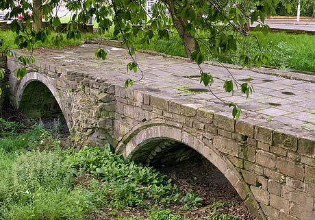
It was equally cold in 1855 when a cricket match was played on the frozen River Trent. The victors roasted, and ate, the greater part of a whole sheep without the ice either melting or giving way. When the thaw set in, an iceberg weighing many tons was unleashed in the river and it destroyed a bridge downstream when it crashed into it.

6419523017_ebf7e7e31c

A local solicitor, William Parsons, recorded the weather’s outrages in his diary:

“In 1814, we had so severe a frost as to freeze the Trent over, the first time I believe. It continued 16 weeks. The Trent was then so frozen that a fair was held and oxen, sheep and pigs were roasted.”

In 1838, the River Trent froze over at the beginning of the year. William’s entry for January 20th reads:

“The frost has now continued about twelve days but with greater severity than is remembered. Many thousands from Nottingham went to see the Trent today. The frost continues extremely severe. The Trent this afternoon is now frozen completely over and I was sliding upon it just above Trent Bridge.  I shall visit it tomorrow again it being of rare occurrence to be frozen. The snow continues upon the ground about six inches deep. My hands are very severely chapped that I am now writing in kid gloves”.

He described the river as:

“in that state frozen it appeared like a frothy, foaming river of snow. Many people were crossing on the ice. I walked down to the bridge and crossed the river just above it where numbers were also winding their way through projecting masses of snow covered in ice. The river was more rough and picturesque in this part than in any other.”

The most charming thing about William’s diary is his great honesty. As regards the consumption of alcohol in very large quantities, he was a man many years before his time:

“Time worse than wasted, money spent, health injured, myself debased! Let these days of drunken, senseless riot be remembered only as incitements to become a rigid teetotaller”.

We’ve all been there.

6419523525_986f696990

The River Trent was a very different river in those days and that is why it used to freeze fairly regularly during exceptionally cold weather. There were, of course, no power stations releasing huge quantities of warm water which might increase the natural temperature of the river, but that is not the most fundamental reason for the change. Nowadays, the waters of the Trent have been for the most part  tamed and confined firmly in great ramparts of concrete. Because of the way in which the river has been turned into a giant canal, it is now much deeper and fast flowing than it used to be. The edges of the river do not extend outwards in leisurely fashion into marshes or shallow ponds with very little flow. The modern Trent no longer stretches, as it did in primeval times, from the sandstone cliffs south of St Mary’s Church for many, many hundreds of yards into present day West Bridgford. And the old wide river, of course, was a shallow, more slow flowing river, the kind of waterway that was much more likely to freeze in severe weather.

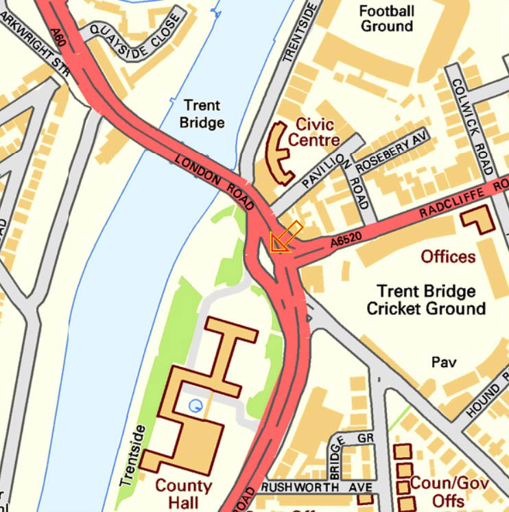
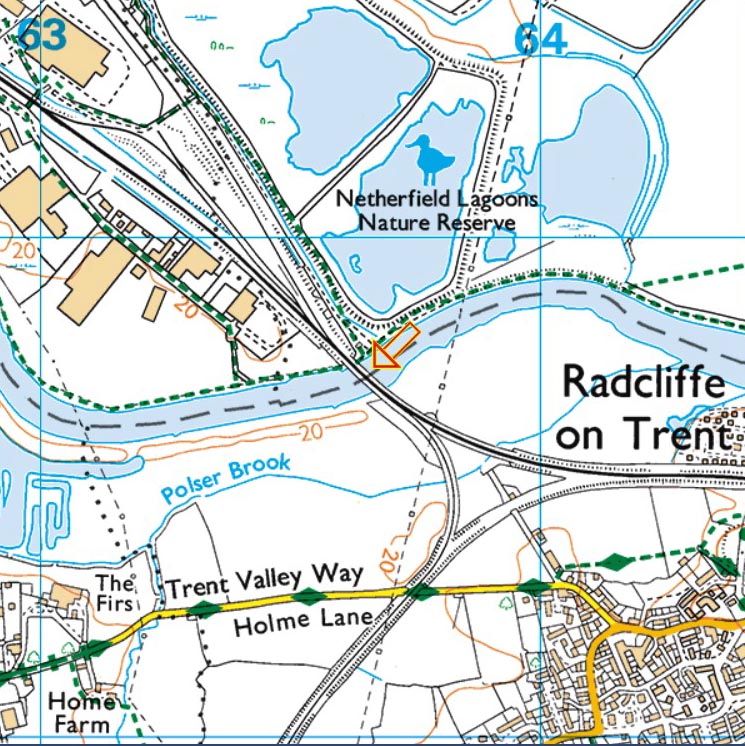
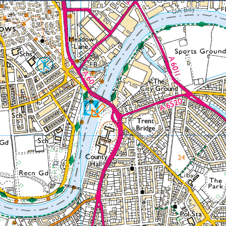
St Mary’s Church is in the top left of the map, near to the word “Museum”. It is represented by a cross and a square joined together. Trent Bridge is indicated by the orange arrow, and the southern edge of the waters centuries ago would have been well to the south of the present day B679 (bottom left of the map) or the Trent Valley Way (top middle right of the map).

old trent bridge

In those ancient of days, when the river was so very much wider, the only safe crossing, either on  foot or on horseback, was across the band of harder rock where Trent Bridge now stands.

images8WR58W3V

On January 16th 1892, on a “piercingly cold” Saturday, Nottingham Forest played Newcastle East End at the City Ground. When the crowd arrived at Trent Bridge, they were surprised to see “skating in progress on the old course of the River Trent.”  Because of the recent introduction of the penalty kick, the frozen football pitch had some new markings, which in this case were made of broad strips of black soot. Newcastle changed from their normal crimson shirts into black and white stripes. Hopefully, before the game, Old Nottinghamian Tinsley Lindley, Forest’s centre forward, was able to walk across the Trent to the game, just like Brian Clough used to do.

NTGM006720

Three years later, in 1895, the river froze for the last time. Again, the region’s economy suffered. Numerous tributary rivers smaller than the Trent were also frozen, and many jetties and warehouses became unusable. This caused huge job losses in local industry.

MS 258/3

The river was caught in this devastating frost for almost a fortnight.  Skaters were able to venture onto the safe and solid ice over many miles of the Trent’s length. The ice was thick enough to allow a hockey game between teams from Newark and Burton-on-Trent to take place on a pitch somewhere upstream from Averham Weirs.

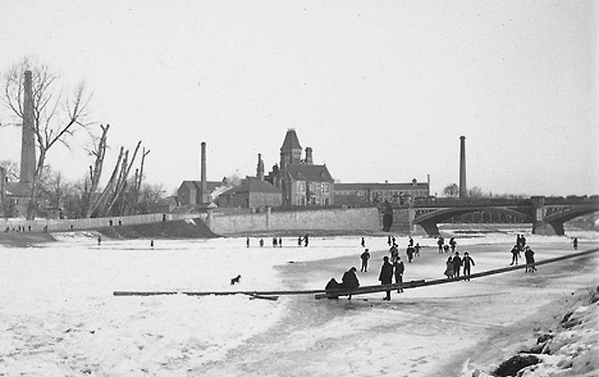
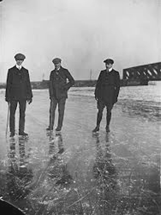
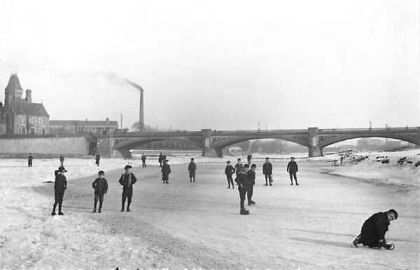
Here a huge crowd of boys are standing on the thick ice. Everybody looks very happy, but there were several fatalities, as people contrived to find excessively thin ice to stand on. Lady Bay Bridge can just be seen through the arches of Trent Bridge.

freezes caption 1

And not a scarf or a pair of gloves in sight. Kids were tough, and Health and Safety hadn’t even been thought of yet.

The photograph above was taken from opposite the West Bridgford embankment, to the south of Trent Bridge, near to the present day County Hall. Look for the orange arrow:

county hall

In places the extreme frost, the most severe in living memory, penetrated into the ground so deeply that it froze the tap water in the mains. Ordinary people suffered greatly and many had no water supply whatsoever, a parlous situation which was to last for several weeks. To overcome this most basic of problems, stand-pipes fitted with taps were set up at various places in the streets, and buckets could be filled up there. January and February of 1895 was a time of difficulty and danger for ordinary people and those who survived it were to remember it for the rest of their lives.
caption 2

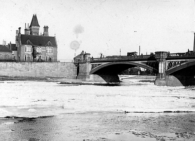
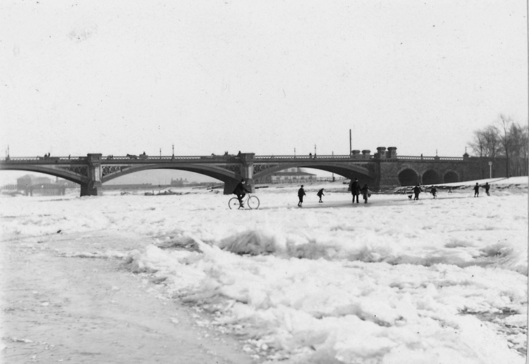
In the photograph above, a fire can be seen burning against the bridge, one of the many which blazed happily on the surface of the ice. The river’s rate of flow is reduced by the ice floes so much that it is almost reminiscent of a river during a drought.

During these bitterly cold winters at the turn of the twentieth century, my grandfather, Will, who had emigrated to Canada around 1905, saw Niagara Falls, for the large part frozen, on at least one occasion, this postcard dating most probably from 1911.

naiagara

2 Comments

Filed under History, Nottingham, Science, Wildlife and Nature

Two local twitches

(An extract from my old birdwatching diary “Crippling Views”)

Monday, September 5, 1988

Another walk around my local patch, Netherfield  Sludge Pits, the Cape May of the Nottinghamshire gravel pits complex. (see the orange arrow)

Untitled

Once again, it turns up the big one, with immediate and excellent views of Sedge Warbler, and a male Reed Bunting in the same fifteen yards of hedge.

This slideshow requires JavaScript.

At the side of the path, there is a little flock of fifteen or twenty Yellow Wagtails and over the main lake, a Common Tern.

This slideshow requires JavaScript.

They used to nest on the little island, until it was submerged by the rising tide of slurry from the local coalmine. Knocking around the fields are a Kestrel, some Jackdaws and a few Stock Doves.

This slideshow requires JavaScript.

On one of the smaller pools, Mute Swans have bred.

Swan_with_nine_cygnets_xxxxxxxxx

They have produced several cygnets, but don’t worry, the anglers lead shot will soon put a stop to that. It’s amazing to think that Curlew used to breed here fifty years ago, and that, at this very site, Black-winged Stilts nested just after the Second World War.

A flock of finches here once contained an Ortolan Bunting and Little Bunting travelling together, and just after the Second World War, there was an apparent family  group of Gull-billed Terns come through, .

This slideshow requires JavaScript.

Today, there are three Great Black-backed Gulls, and a Herring Gull.

That’s what the destruction of habitat is all about.

**********************************************************************************************
Wednesday, September 7, 1988

An evening trip this time. A local birdwatcher has told me about a superb new place that attracts wonderful birds by Nottinghamshire’s normal standards. It’s a couple of flooded meadows down by the River Trent at Stoke Bardolph (now, alas, with houses built on them). Look for the orange arrow:

This slideshow requires JavaScript.

For some reason, the farmer has allowed the fields to flood, and for an even more obscure reason, he has permitted them to remain flooded. Waders in unprecedented numbers have been attracted for a short stopover as they fly south down the Trent Valley to Africa. Previously, I would only have thought of Stoke Bardolph for the incredible stink of the sewage works that are down there, but this is really something else. It’s just like a hide at Cley-next-the-Sea, with Curlew Sandpipers, Spotted Redshanks, a dozen or so Dunlin and some Greenshanks.

This slideshow requires JavaScript.

There is  a single stint, which causes us a little excitement as Steve and I try very hard to turn it into a Temminck’s Stint.

Temmincks_zzzzzzzzzzzzzzzzzzz

But it must, unfortunately, stay as a Little Stint. Still, it was a good try.

Little Stint1zzzzzzzzzzzzzzzzzzzzzzz

The only negative thing about the whole evening is the failure of the Hobby to appear at the appointed time.

Hobby xxxxxxxxxxxxxxxxxxxxx

There is at least one, if not two, birds in the area, and it, or they, often hunt over the woodland on the opposite side of the river. It’s even been seen knocking around in the gardens of neighbouring Burton Joyce, a riverside village. Tonight, though, there’s nothing.
Never mind – it’s a really brilliant wader site for somewhere as far from the coast is this. What a pity, therefore, that only a few months later, despite the impassioned pleas of a number of different conservation bodies, the farmer  should plough up the land without compunction, and what could have been a brilliant inland nature reserve is lost forever. So much for a democratic society. We are about as democratic as the Democratic Republic of East Germany is democratic. If you own the land, you can do whatever you like with it, irrespective of how many people subsidise you with their taxes and would like some kind of input as to what is done with the land.

Leave a comment

Filed under Nottingham, Politics, Twitching, Wildlife and Nature